
 So how do we explore for Porphyry Copper Deposits which are completely covered by barren younger rocks? Well let’s back up a bit, we know that porphyries form under large subduction related volcanoes and that most of these are located under the ring of fire around the subducting pacific plate another fertile subduction zone occurs in Balkans, Turkey, Iran and Pakistan.
 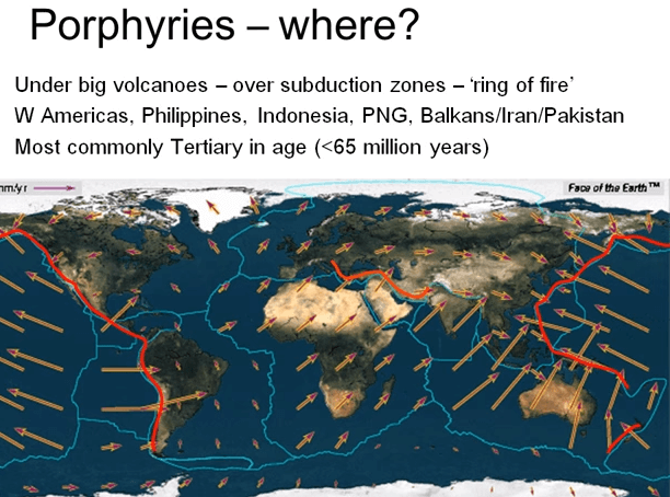 So this gives us a start in deciding where to focus our exploration because of the extensive subduction during the tertiary i.e. in the last 65,000,000 years many porphyry deposits are of this age in other words porphyries are relatively young by geological standards; just put that comment in context although 65 million years sounds a long time ago if the earth’s history was compressed into the equivalent of a single year the tertiary would occupy just the last five days of December.
So once we focus our exploration on the subduction zones where porphyries could potentially have developed we need to find the actual intrusive and their associated mineralization; how do we do that when the mineralization may not actually out crop? The key to porphyry exploration is the alteration of the surrounding rocks that occurred during the intrusion and mineralization. The so-called prophylactic folic and potassic alterations I spoke about. Identifying the distribution of alteration allows us to vector into the mild, low temperature prophylactic alteration and then towards the hotter more intense potassic alteration that generally hosts the bulk of the mineralization. In porphyria exploration if you don’t see significant alteration you’re probably not close to mineralization unless the rock postdates the mineralizing event. Delineation of the alteration can be done in several ways, obviously if the alteration outcrops straightforward field mapping will identify the telltale alteration minerals; chlorides, calcite and epidote of prophylactic alteration, quartz, sericite and pyrite or folic alteration and potassium feldspar, biotite and magnetite, quartz and base metals sulfides of potassic alteration.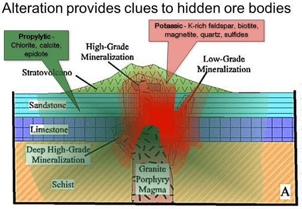
There is no proper substitute for getting underground and mapping an area in detail but there are other ways of vectoring in on the most prospective areas prior to expanding this boot leather and satellite imagery is one of these tools.
The images of visible spectrum satellite image of a porphyry mine in the Chilean Andes you can see the open pit and the leach pads as well as the white dust covered areas surrounding the mining operation beyond that you can see the brown and gray volcanics, what you can’t see is the mineralization and the alteration of the volcanics. Reprocessing that exact same image for that exact the same image for an invisible infrared portion of the spectrum shows up this alteration as green in the case of pink or red in potassic alteration. From this you can see that the open pit is pink and purple in color reflecting the potassic alteration of the ore but there is a strong circle area of pink potassic alteration to the north of the existing pit that probably warrants drilling. There are a couple of other smaller spectrum anomalies that should also be checked out. You can see other pink areas down in the bottom left for example and some of these may indeed be potassic alteration but others are probably false anomalies caused by volcanics that are naturally rich in potassium feldspar rather than caused by the hydrothermal alteration. Satellite imagery as with most forms of geophysics usually generates a large number of false anomalies as well as a few real ones sorting out the truth from the false is largely a matter of experience and then field checking.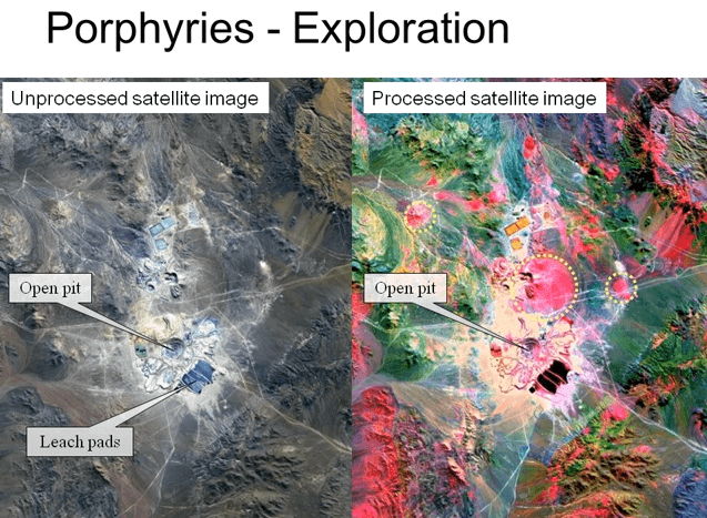
Satellite imagery works very nicely if the alteration out crops its surface but if the porphyry has been partially eroded and then covered by later post mineralization volcanics or sediments, satellite imagery can’t penetrate below the surface in search of limited use. If the alteration isn’t within a couple of millimeters of the surface literally right on the surface this satellite will simply not see it, In this case we need to use geophysics to penetrate the overlying rocks and see what’s hidden below and there are several geophysical tools that can assist. The quickest way to detect the intrusive is by using the airborne magnetic survey.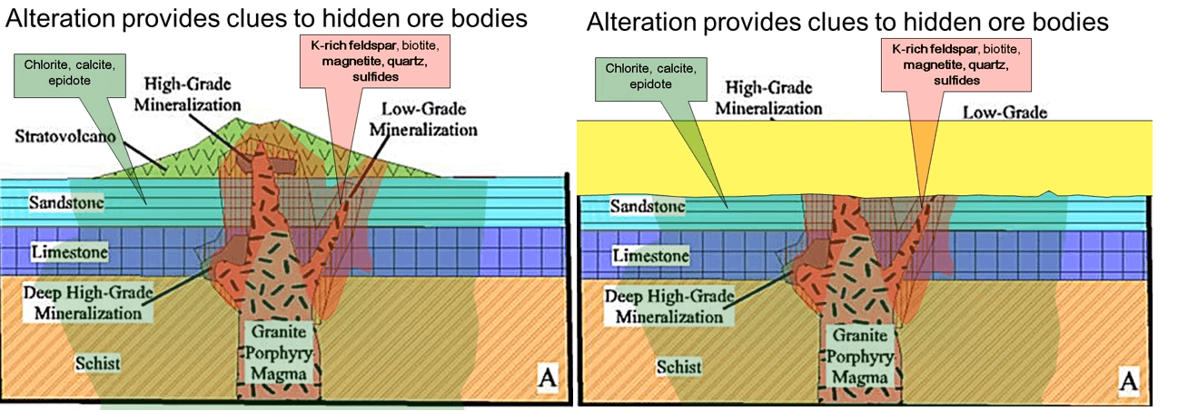
The potassic alteration process generates magnetite and so it may give a positive magnitude anomaly. The image shows the magnetic data of a Fruta Del Norte in Ecuador. The epithermal gold mineralization at the top of the image is not detected by the magnetics except as a break between the blue and the green which may indicate a fault, however are blind porphyry intrusion the camp porphyry on the left of the image stands out clearly on the magnetics unfortunately at this stage it is too low a grade and too deep to be economic. As second geophysical in induced polarization or IP. This entails putting short burst of current into the earth through electrodes and measuring how long it takes for the signal to dissipate. This signal can detect disseminated sulfides but not massive sulfides. The shortcomings of the method is that it’s generally reliable only down to 250 or 300 m depth although some of the newer systems may extend this to about 500 m deep. If the cover rocks are thicker than that or weathering has oxidized the sulfides to deeper than this, IP is of little use. A third method of geophysics that may possibly be able to detect exposed but not buried alteration is radiometrics it’s usually flown at the same time as a magnetic survey in can detect radiation when the potassium is potassic alteration. The lower image is of the Mount Milligan porphyry British Columbia and the potassic alteration stands out clearly on the radiometrics as the high purple magenta blob on the top left.
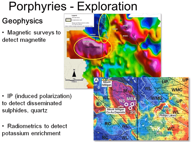
Now all three of these geophysical methods are indirect; used to detect the alteration and not necessarily the mineralization. We still don’t know how much copper, gold or molybdenum the rocks contain and whether they have received enough upgrading from the crustal average to be economically mined.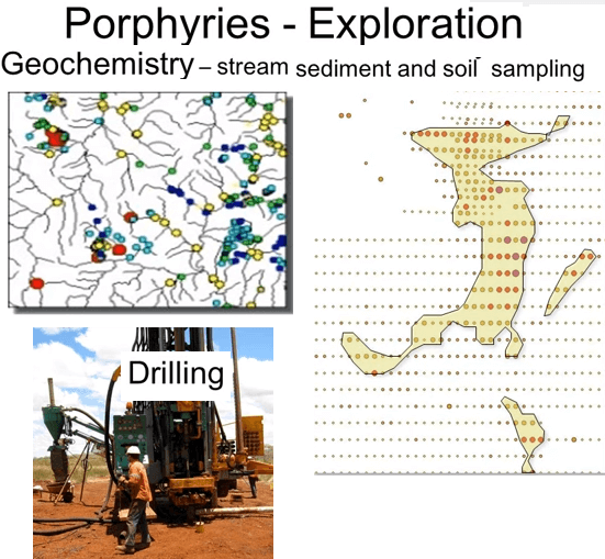
We need chemical assays to determine this. This may entail straightforward surface sampling with mineralization out crops near surface. Stream sediments, geochemistry is a cheap method of first pass evaluation. It involves assaying samples taken from stream beds working on the principle that the sediment is being eroded from somewhere in the catchment area of that stream. Samples are usually taken from so called second order streams the ones that drain only a limited catchment area so it’s possible to narrow down the source of an anomaly pretty quickly. The image shows the results of one of these surveys again from Lundin’s Fruta Del Norte concession. The anomalous red samples identified three catchment areas that warrant further follow-up fieldwork. Stream sediment anomalies are usually followed up with a regular grid of soil sampling to identify the source of the stream sediments. Anomalies can be very tightly defined using soil geochemistry and usually wet enough to allow you to site a drill hole. As with almost all ore deposit types porphyry targets need to be drilled eventually to quantitatively determine actual copper, gold and molybdenum values in the identified mineralization. I’ll talk more in detail about drilling and the drill techniques in a later course.