
Table of Contents
Failure to sample and estimate properly the available yardage of placer deposits has resulted in a tremendous waste of money and effort. A large proportion of all placer operations has failed because the gold in the gravel was insufficient to repay the cost of even the most efficient mining, not to mention the return of money invested or interest thereon.
Many methods of sampling are available, including the simple panning of gravel from natural exposures, drifting, test-pitting or trenching, shaft-sinking, and churn-drilling. Actual mining on a small scale often is done as a method of sampling prior to investing considerable money in development or equipment. Several examples will be noted later under methods of mining.
The technique of panning and its use for estimating the gold content of gravel are discussed under the head of Panning and Rocking, as these operations are properly considered small-scale mining methods. In the following section the more elaborate methods of sampling are discussed, and costs are given where available.
Weight of Placer Gravel
Placer gravels vary greatly both in weight per cubic yard in place and percentage increase in volume on being loosened. Yet in making estimates of yardage and value it often is necessary to use some factor to convert volume in place into loose volume or into tonnage. In common placer terminology “heavy” gravel indicates coarse rather than weighty material. The weight is greater in tight or cemented than in loose ground, and it increases with the proportion of large boulders and heavy rock material such as diorite, greenstone, or hornblende schist. The amount of moisture present likewise affects the weight.
Three contiguous samples taken by the authors from the same bed of tight, fine clayey gravel overlying a pay streak in the Greaterville district, Arizona, indicated weights of 3,450, 3,540, and 3,000 pounds to the cubic yard, respectively, or an average of 3,300 pounds. A sample of clean gravel with 30 to 40 percent cobbles over 2½ inches in diameter, from another gulch in the same district, weighed 3,600 pounds to the cubic yard in place. The samples contained 5 to 8 percent of moisture. The expansion of the first three samples was- 50, 54, and 33 percent, respectively, an average of 46 percent. The last sample expanded 17 percent.
The gold-bearing river gravel at the pit of the Grant Rock-Service Co., Fresno, Calif., weighs 2,850 pounds per cubic yard. Some engineers in calculating tonnage allow 3,000 pounds to the cubic yard, bank measure. Handbooks give weights per cubic yard ranging from 2,600 to 3,650 ponds. An average weight probably is between 3,000 and 3,300 pounds to the cubic yard.
Sampling Natural Exposures
Whenever a gold pan is used the result not only proves or disproves the presence of gold, but also usually, shows accurately the amount of gold contained in the sample chosen. Panning along a creek bed thus is the most elementary method of sampling a placer deposit. However, the samples commonly, are taken so as to render the quantitative results worthless.
A gravel deposit of much size seldom can be sampled directly from its natural exposures; but a few creek banks, steep-sided gulches, or old excavations such as hydraulic pits may be available, in which case certain precautions should be taken to get true samples. First, the vertical extent of gravel to include in a given sample should be determined. If hydraulicking is to be done, the whole depth of gravel ordinarily is included in one sample, except when it is planned to pipe off the barren overburden to waste, in which event it is desirable to know the depth of barren material and samples may be taken of each distinguishable stratum. If drifting is planned, only the lower, economically minable gravel need be sampled. After the location and extent of a sample cut have been decided, care must be taken to have equal quantities of gravel from all points along its length. The best way to do this is to cut a channel or groove of uniform shape and size from top to bottom of the sample distance. Enough such samples must be taken to prove the continuity of the “pay streak.”
Mechanically the procedure of sampling a gravel face resembles closely that pursued in lode mines. A pan and a pick are the requisite tools. The bank should be trimmed well and cleaned along the sample line to eliminate effects of surface weathering. The pan may be used to catch the loosened material, or a canvas may be spread on the ground. If conditions favor it, a measurable channel or groove should be cut so that the volume taken can be measured. Otherwise, the only alternatives are to use a factor for pans per cubic yard or to measure the loose gravel in a box which has been calibrated in terms of bank measure.
Drifting
Drifting is a common method of prospecting a deep placer deposit when conditions are favorable. Methods and costs of drifting are discussed briefly under Drift Mining in a subsequent paper. The cost of driving a small drift in placer gravel ordinarily ranges from $2 to $6 per foot. Difficult ground conditions or excessive water may increase the cost to $10 or $15 per foot.
For sampling purposes, the gravel usually is taken to the surface and concentrated in sluice boxes. If an old drift is being sampled various methods may be followed. If the ground will permit, the most satisfactory method is to slab 1 or 2 feet, from the side of the drift and wash the gravel thus broken. If not, vertical channels may be cut on one or both sides of the drift at intervals of about 5 feet. If the latter is done, the volume of the sample cut may be measured, which is preferable under most conditions, or a factor may be used for reducing loose measures of gravel to solid measure, which facilitates taking the sample but introduces some uncertainty and leads to carelessness in sampling. If values are to be expressed in cents per ton it is still necessary to decide what conversion factor to use in making estimates of tonnage.
Test-Pitting
Test pitting, and trenching are applicable only to gravels so shallow that a man can throw out the dirt by hand. The best procedure is to mark out the area of the pit on the surface, making it rectangular, as small as convenient, and preferably in dimensions of even feet such as 2 feet wide and 3 or 4 feet long. Then it should be excavated to bedrock with smooth, vertical walls. Sometimes a cleared space is prepared and the dirt thrown on the bare ground, but in view of the greater difficulty and possible small error involved in rehandling the dirt it is better to shovel it onto a canvas or board platform or into a receptacle. If a large boulder projects into the pit no correction of the theoretical volume of gravel should be made, regardless of whether or not the boulder is removed or allowed to remain in place-as obviously it cannot be ignored, in mining operations and is the equivalent of so much barren gravel. The gravel taken from the pit may be thrown into one or more piles, depending, on whether or not information is desired, regarding one or more individual strata. Sometimes alternate third, fourth, or tenth shovelfuls are used for the sample to reduce the volume to be panned or otherwise concentrated. This should, be avoided whenever practical
because of the possible error introduced.
The cost of sinking test pits or running trenches in earth and gravel has been noted often enough for fair generalizations to be established. Gardner states that opencast work in placer ground costs from $0.40. to $1.00 per cubic yard, depending, on the nature, of the ground and on wages. Wages for such, work then ranged from $3 to $4 per 8 hours. Furthermore a man should be able to pick and shovel, about 8 cubic yards of fairly loose, gravel in 8 hours. In test pits the worker’s efficiency would be lowered somewhat by the cramped quarters and by the care necessary to square out the corners and- trim the sides to vertical planes.
Near Skull Valley Ariz, an area of shallow gulch placer ground was being sampled by test, pits in 1932. The gravel was moderately fine and loose, angular to subangular wash, 2 to.6 feet deep. Mexican laborers at $3 per. day were able to dig an average of five test pits per 8-hour man-shift. The pits averaged 2 feet wide, 3 or 4 feet long, and 3½ feet deep. The cost of digging the pits was therefore about $0.65 per cubic yard.
The gravel was shoveled first onto the ground beside the pit. Usually, all gravel was hauled by truck to the washing plant, an average distance of about three fourths mile. If a pit produced more than about 1 yard of gravel the sample was reduced in size by quartering. The sampling was done near a well on Copper Basin Wash. The gravel was shoveled from the truck directly into the hopper of a small screening, washing, and concentrating device mounted on a trailer. A 1-inch centrifugal pump on the trailer took about 15 gallons of water per minute from a large tank on the hillside and forced it through the sprays of a double trommel screen, in which the gravel was washed; all material over about one eighth inch in size was rejected. The fines were concentrated in a patented 12-inch centrifugal bowl. The plant-was said to have a capacity of 2 to 3 yards per hour. It was driven by a 1½-hp. gasoline engine. Water was pumped from the well to the storage tank by a 3½-hp. gasoline engine.
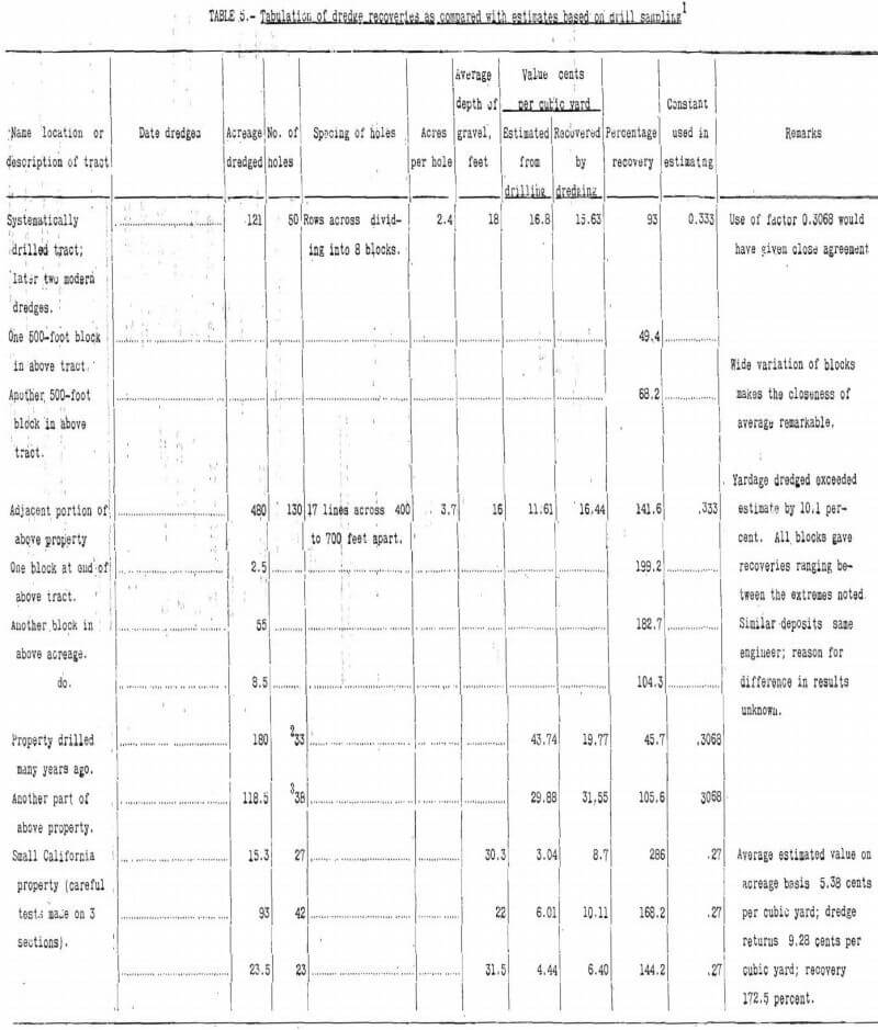
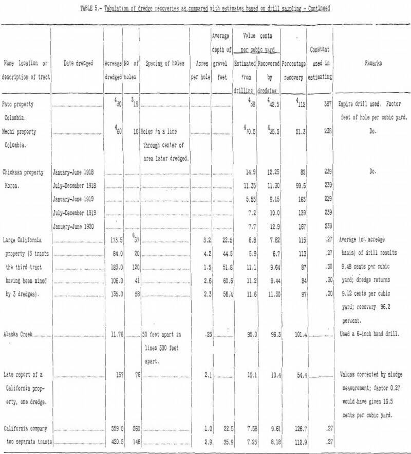
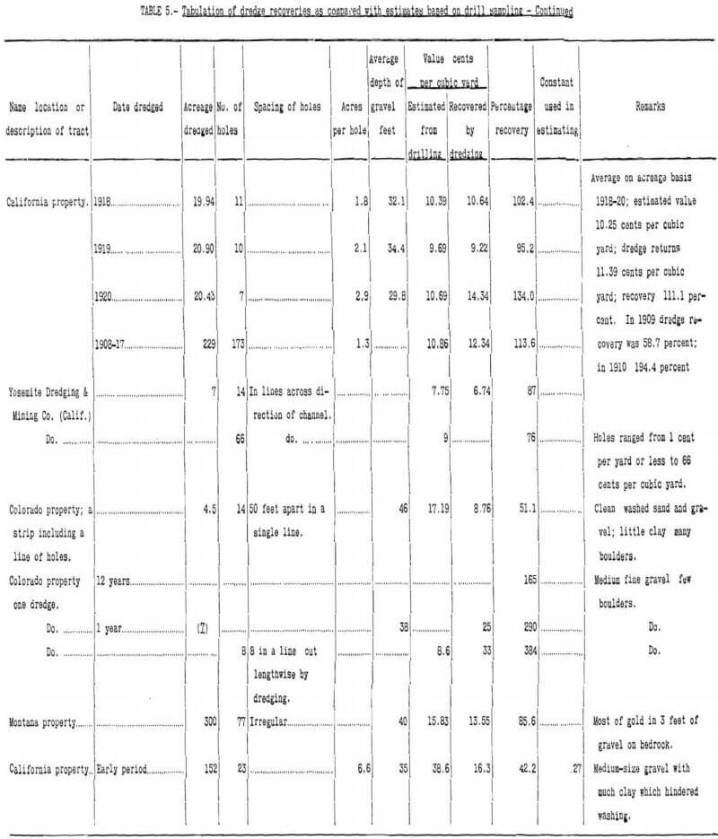
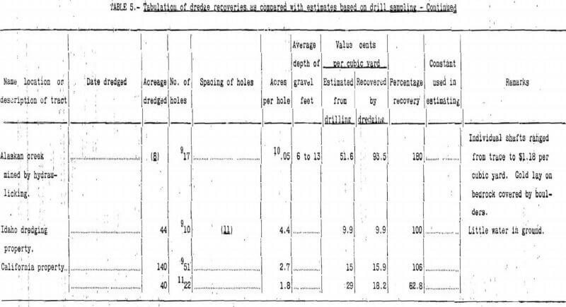
The spacing of test pits depends on the nature of the deposit. If the pay gravel occurs in narrow channels the best plan is to space the pits in lines across the channels, as is done with churn-drill holes when sampling dredge ground. The holes must be close enough to yield an average value which represents the average value of the channel at that point. In practice the spacing ranges from a few to 50 or 75 feet, depending on the uniformity of results. The transverse lines of pits theoretically should be placed close enough to show either fairly uniform values from line to line or a reasonable upward or downward trend of gold content along the channel. Unfortunately, this is seldom possible, and the usual practice of spacing the lines from 100 to several hundred feet apart is a compromise in the engineer’s mind between the cost of sampling and the need for accurate results.
Geophysical Prospecting
In the last decade geophysical prospecting has been applied to placer mining. Where the bedrock is of Homogeneous or uniform magnetic permeability and where considerable magnetite is associated with valuable gold concentrations, magnetometer surveys can outline these leads quite accurately. The instruments used most for this purpose are the Thompson-Thalen, Askania Schmidt field balance, and Hotchkiss Superdip magnetometers, which measure slight changes in the intensity of the earth’s magnetic field. Operation of these instruments is not difficult, but correct interpretation of the results requires experience.
Where uniform bedrock conditions do not exist the magnetic work must be supplemented with electrical work to obtain complementary data for use in interpreting the magnetic anomalies. The electrical work gives information on thickness of gravel and depth to bedrock, contour and outline of the underlying bedrock, and other structural features which may be of value in planning the mining operations. It also gives height of the water table.
At one proposed hydraulic operation in northern California application of these methods showed that the bedrock slope was quite different from what had been thought and that a buried fault of considerable displacement crossed the property, both facts being of prime importance to the operators. The cost of a combined magnetometric and electrical survey at this property was approximately $2.00 per acre for 600 acres. The results of the survey, made by 2 engineers and 2 assistants in about 30 days, were set forth in a surface topographic and geologic map, a bedrock contour map, and numerous vertical sections across the channel. From these data yardage estimates were made, also recommendations for sinking a few shafts and driving a tunnel on bedrock at points where a maximum of information as to gold value could be obtained.
It must be emphasized that no geophysical method or combination of methods is offered by reputable engineers as a means for determining the commercial value of placer-gold deposits. However, information gained by geophysical methods as to the physical features of the deposit are of great value both in subsequent testing and in developing and operating the property.