The following are the various divisions under which rocks may be classified:
IGNEOUS
- Rocks which have been subjected to heat.
- Volcanic (those that have been cooled at or near the surface) :—
- Trachyte (rough, greyish in colour, and light in weight).
- Basalt (blackish or brown, heavier and with fewer holes in it than trachyte). Phonolite, Andesite (of which porphyrite is an altered variety).
- Dolerite (with crystals more prominent than in basalt) : elvans (including quartz-porphyry) : pitchstone, &c. These last three occur as dykes or intrusive sheets : the two last are offshoots of granite formations.
- Obsidian (usually transparent and like bottle glass, pumice, &c.): rhyolite, &c.
- Plutonic (those that have cooled at some depth below the surface) :—
- Granite, porphyry, syenite, diorite, gabbro, &c. ; these usually have a distinctly crystalline structure, frequently with large crystals.
METAMORPHIC
- Of igneous and aqueous origin, but which have undergone a change by pressure
- Gneiss (in composition like granite, but foliated).
- Mica schist (quartz and mica), hornblende schist, talc schist, chlorite schist, diorite schist, are some of the foliated forms. Quartzite and some serpentines are metamorphic.
AQUEOUS
- (Deposited by liquid agency.)
- Gravel (made up of loose rounded pebbles), conglomerates and breccias.
- Grit (in which the grains, usually of quartz, are cemented together).
- Sandstone (in which quartz grains are very fine).
- Sand (in which the grains are loose).
- Clay (silicate of alumina and of a plastic nature). Slates (hardened clay, which displays cleavage across the bedding).
- Shales (hardened laminated clay).
- Marl (clay containing carbonate of lime).
- Loam (clay mixed with fine sand).
- Flint (nearly pure silica).
- Limestone, chalk, marble, &c. (made up of carbonate of lime).
- Delomite (carbonate of lime and magnesia).
- In addition to these may be mentioned volcanic ash, deposits from hot springs.
With regard to the age of granite, which formerly used to be considered the oldest rock, and also that of the metamorphic rocks, the latter are of various ages, and really represent certain rocks metamorphosed. 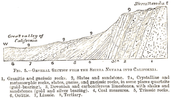 It is supposed, from its nature, that granite could not have been subjected to a very great heat (although I have classed it as igneous), and though, while evidence does not deny that the basis of rock formations may be granite, still it shows that the intrusive granitic rocks which are met with in the crust of the earth belong to various ages; and it may be taken for granted that the formation of granite in another geological formation is newer than the rock which it penetrates and older than the strata deposited on it.
Not only are rocks deposited by the agency of water in the form of strata, but their beds also are made up of thin laminae, or leaves (Fig. G), and sometimes the laminae lie unevenly (Fig. 7).

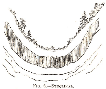
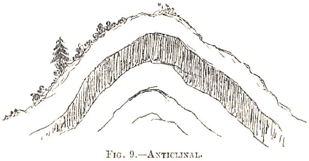
Stratification is by no means always horizontal, for the beds sometimes dip considerably, and sometimes have been bent by pressure or strain into curves. When the beds are bent into ridges or troughs for considerable lengths they are called respectively anticlinal and synclinal (Figs. 8, 9).
When one series of strata is parallel to another, the two are said to be conformable; when not parallel, unconformable, as in Fig. 10.
In this illustration the one set of strata (dipping 45°)
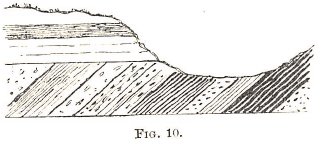
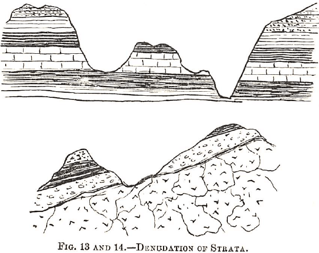
has been tilted up from its original horizontal position ; after which the horizontal strata were deposited. The wearing away of rocks may be produced by various denuding agents, such as wind, rain, running water, sea, frozen water, &c. Sometimes the water acts chemically and
rots the rock, while rivers and rain dig and saw, the sea planes, the expansion of ice splits, and glaciers file it. As to weathering well, the sandstones seem to be less liable to disintegration than most rocks, unless they contain iron or carbonate of lime; limestones are readily attacked by water.
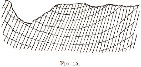
“While some rocks can be split along the layers as originally deposited, other fine-grained ones, such as slate, can be most easily so in a direction across the line of bedding. In contorted strata the lines of cleavage are parallel, as in Fig 15. Cleavage is probably due to lateral pressure.
Most rock masses (from shrinking, in aqueous rocks; and cooling in igneous rocks) are divided into blocks, sometimes quite regularly, by means of what are called joints. Deep in a mine, these joints fit closely; not so at the sur-
face. Most frequently the direction is at right angles to the planes of bedding. In sandstones the joints are irregular, and the blocks of different sizes; in limestone, the joints are fewer than in shale and some kinds of slate, and
the blocks are generally cuboidal, the vertical joints being very regular. The valuable minerals and metal-bearing deposits of the earth are found as—
Lodes, the ordinary fissure vein running through various strata, and the gash vein, though wide at the surface, pinching out.
Beds of ore, interstratified between other beds. For instance, coal, iron ore (especially in the Oolite formation), copper ore in shale, silver and lead ore in sandstone, &c. Deposits irregularly stratified. Contact deposits between two formations where the deposit lies on the older one, &c.
Irregular deposits, such as pockets, &c., which lie sometimes in various formations. Contact deposits, network of veins, and where mineral is diffused through rocks, or in small cracks, or in dykes, or scattered about country rock near the walls of a lode.
Superficial deposits, such as nearly all the diamond and gold alluvial diggings, stream tin deposits, &c.
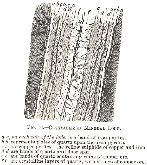
With regard to the nature of the veins in lodes, the metal- bearing minerals are scattered throughout the vein stuff, or in nests and strings; sometimes they may be found next to the “ hanging” and “foot” walls, or in many cases in regular symmetrical layers between layers of the different substances in the gangue, as in Fig. 16.
The angle which the plane of a stratum or lode makes with the horizon is called the dip; the line where the plane cuts the horizontal plane is called the strike. As it is of paramount importance for the geologist to thoroughly understand the full meaning of these terms, the following explanation will be of use.
If a sheet of note-paper be held so that one leaf is horizontal and the other hangs down, the angle which the latter makes with the former is the dip, and the line where the two leaves are connected is the strike. Suppose the plane of the lower leaf sloped towards the east and made an angle of 45° with the horizontal leaf, it would be said to dip 45° E., and the strike (which is at right angles to the direction of the dip) would run north and south. The line in which a stratum or lode cuts the surface is called the “ outcrop,” and where the surface is level the direction of course can be measured by the “ strike.”
In measuring the dip of a bed, or lode, or slope of a hill, the eye can be of great Service in doing so approximately; but an instrument called the clinometer is of more use when accuracy is required. Various kinds of this simple instrument are to be met with, some having a prismatic compass and a spirit level in the same apparatus; the principle,
however, is the same in each. A very simple one can be easily made as follows. On a rectangular piece of wood or cardboard describe a semicircle as in Fig. 17. From c, the centre of the whole circle, draw C D at right angles to A B. Divide A D into 90°, and D B into 90°, placing the zero mark at D, and the divisions 10°, 20°, 90°, as in the illustration. Let a plumb-line, such as a piece of thread with a small weight at the lower end, be suspended from a nail or small pin at C.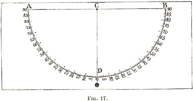
Now, when the upper edge is held horizontally, the plumb- line will pass over the zero marking and hang vertically; when held parallel to the line of bedding, or lode, or slope of a hill, the plumb-line will be inclined a certain number of degrees to the fixed line C D, and the number of degrees read on that point of the semicircle over which the plumbline passes will indicate the inclination of the bed, lode, or slope of a hill to the horizon, i.e. the dip. A clinometer and compass may be combined in the same apparatus by fixing a small pendulum to the centre of the compass directly under the magnetic needle.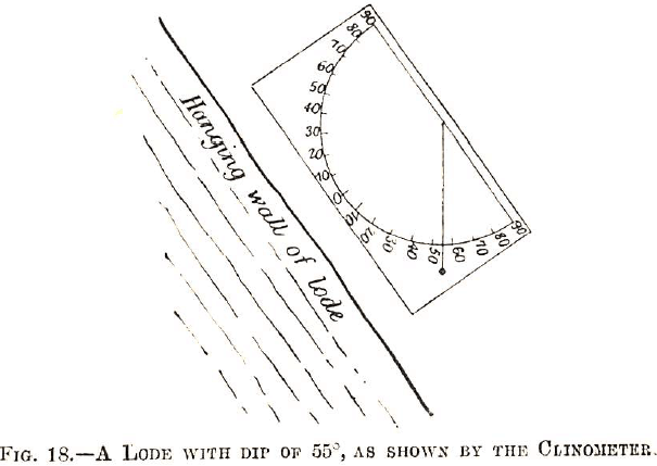
To use the compass, hold it horizontally in front of the eye, and note the number of degrees which the direction of the line looked along makes with the magnetic north as shown by the needle. The ordinary magnetic compass should be divided into degrees, so that between N. and E. are 90° ; E. and S., 90°; S. and W., 90°; W. and N. 90°.
Suppose the observer looking along the strike of a lode notices that its direction is 30° from the north towards the east, the direction is said to be 30° E. of N. Although the prospector in his calculations will probably only note his readings from the magnetic north, it may be well to remind him that the magnetic north differs from the true north. If the latter is required at any time it can be found by noticing the shadow which a vertical post casts at noon.
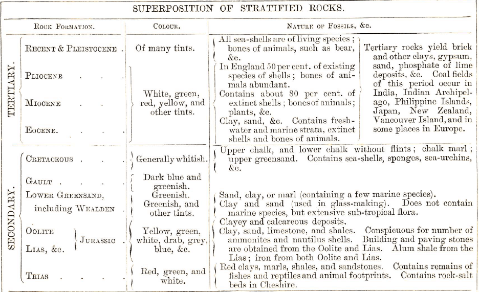
Rocks classified.—Superposition of stratified rocks.—Lamination.— Stratification. —Denudation.—Cleavage. —Joints. —The condition under which metal-bearing deposits are found.—Nature of mineral veins in a lode, &c.—Dip.—Strike.—Clinometer.—Compass.
