
Here is some history of the Witwatersrand Gold Style Ore Deposits as they related to South Africa since the arrival of the Dutch and the southernmost tip of the continent in 1652. The Dutch set up a small fort where Cape Town stands today and started Market Gardens as a place that the Dutch East India Company ships to shelter and to restock with freshwater and provisions on the long journey between Holland and East Indies. The East Indies was a vital spice trading destination for the Dutch.
As time went on the tiny community expanded and some of the Dutch were allowed to move into the surrounding area to set up new farms on the condition that they still sell their produce to the Dutch East India Company to supply the expanding ship traffic. This arrangement although it was very successful only lasted for a fairly short time before these farmers or Boers as they became known became frustrated by the restrictions set by the company and they started breaking free of the bond and moving inland in their wagons with the Bible in one hand and the rifle in the other.
Towards the end of the 1700’s the global influence of the Dutch began to fade and the British moved to fill the vacuum that they left. By 1815 British sovereignty of the Cape was recognized by other European Nations. The influx of British settlers and the imposition of British law infuriated the Boers and they began moving east to escape the British influence although much of the area that they moved into was pretty inhospitable there were still a tough group and they thrived there.
In 1820 the British began their settlement of the Eastern Cape initially as a way of providing a buffer between the advancing Dutch settlers and the indigenous groups to the East. This idea failed but the British were there to stay and they rapidly expanded up the East Coast and then inland. Hindered by the British to the West and the East and by the ocean to the South the Boers climbed into their wagons again and they headed North East seeking new horizons where they can live their lives free of the hated British. They crossed the Vaal rivers and setup two new Boer Republics; The Orange Free state and the Vaal Boer Republic electing their own presidents.
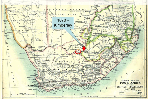
In 1866 a large diamond was discovered on the banks of the Orange River in unclaimed land near the border where The Orange Free state. Three years later and even bigger one was found some miles away on a small rocky hill known as Coleman Cop. Within months of word getting out there’d been a huge diamond rush and by 1870 the area was blanketed by more than 800 claims. The Cape colony, The Transvaal, The Orange Free state and the local indigenous feeder from the Greek tribe all laid claim to the area. The courts awarded the mineral rights to the indigenous leader he then placed himself under British protection and in 1871 the area was proclaimed part of The Cape Province.

Within two years of thriving tent and wooden shack city that became known as Kimberly had sprung up with thousands of miners working tiny claims by hand hauling the ore out of the pit on a spider’s web of cable hoists. Cecil Rhodes arrived in South Africa from England in 1870 to help on his brother’s farm in Natell but within a year he’d given up the farm and he joined the rush of Kimberly’s diamonds. Over the next 17 year he steadily brought out all the small claim owners until he achieved a monopoly. The DeBeers consolidated mines was established in 1888 but along before that thousands of prospectors and miners who had arrived at Kimberly too late to stake a claim for them had moved on in search of the next Kimberly or El Dorado. But where was that next opportunity?
North of Kimberly towards the Kalahari Desert the land became drier and more inhospitable so most prospectors fanned out to the North East and the East of Kimberly into the Transvaal Boer Republic. Steadily new discoveries were made not of diamonds this time both of gold. armed with their prospecting plans the new wave of fortune hunters crushed and panned any cortsvanes that they could see looking for telltale flakes of gold, by 1870 gold had been discovered in the Murchison in the north of the Transvaal a year late at Eersterling and in 1873 in the mountains around Sabe and Pilgrims rest and in 1881 the Barberton Green gold field was discovered. Now most of these gold discoveries were of what we now call share zone hosted green zone gold deposits, cortsvanes in green zone belts and at each of these places the same tent and shack towns sprung up and word went out joined the fortune hunters and the losers would arrive too late to cash in on the previous discoveries.
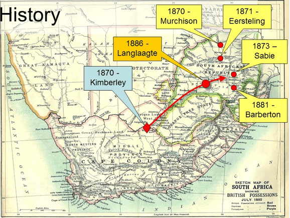
One of these down on his luck diggers and Australian called George Harrison arrived in Kimberly when Rhodes had already tied up most of the diamond diggings. Unable or unwilling to work in Kimberly for a pittance he decided to walk 500 miles to the new gold discoveries in the Eastern Transvaal. He set out from Kimberly early in 1886 travel through the Transvaal Republic prospecting and panning the streams as he went, His route took him over the open grassland to the Highveld with its scattered Boer farmsteads including one called Langlaagte or Long Valley named after a valley that ran parallel to a barren cortside twitch.
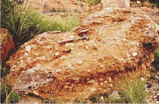
There on a Sunday morning in March he spied an out crop of unusual rock. It was a pebbly conglomerate. Now there were no cortsvanes of the sort that were usually associated with gold in his native Australia or the new discoveries in the Eastern Transvaal but he knocked off a piece of it anyway and he noticed among the partially oxidized pyrite the gleam of gold. He went to the local Transvaal Republic government offices and lodged a claim once word got out he’s sold his claim for 10 pounds and then he continued his trip to the Eastern Transvaal gold fields; his original target he was never heard of again.

There is a statue of George Harrison on the site of his discovery in what is now one of the Southern suburbs of Johannesburg. It shows a rather romanticized view of Harrison holding up a lump of rock perhaps shouting eureka. More likely he was mutted, doesn’t look much good but may be able to flog the claim to some idiot so I can buy enough food to get me to Barberton but the staking of that claim next to the ridge white waters or Witwatersrand was the start of the greatest gold field in the history of the world. In a matter of a few years the area went from a barren wasteland through tent city, to shacks, to brick buildings to a bustling metropolis with its own stock exchange and secondary industries. Within 10 years it had out stood Cape Town as the biggest city in Africa south of the equator a position that still holds today.

The original out crop of the reef runs under the low building in the foreground of this picture of Johannesburg with a tall hill brown tower at back left built on the ridge of White waters.
So much for the discovery of the Witwatersrand gold fields. Let me try to convey now just how big and significant these really are. As many penny stock investors were very familiar with vane type gold deposits that may be a few meters thick with a strike of a couple of 100 m to a couple of kilometers. Such a deposit might contain anything from 100,000 ounces to 10,000,000 ounces of gold but when we think of an example of a huge deposit we might turn to a monster such Bingham Canyon in Utah.
Bingham is a very large porphyry deposit with an open pit that dwarves the giant ore, tracks the transport ore to the input trail system.
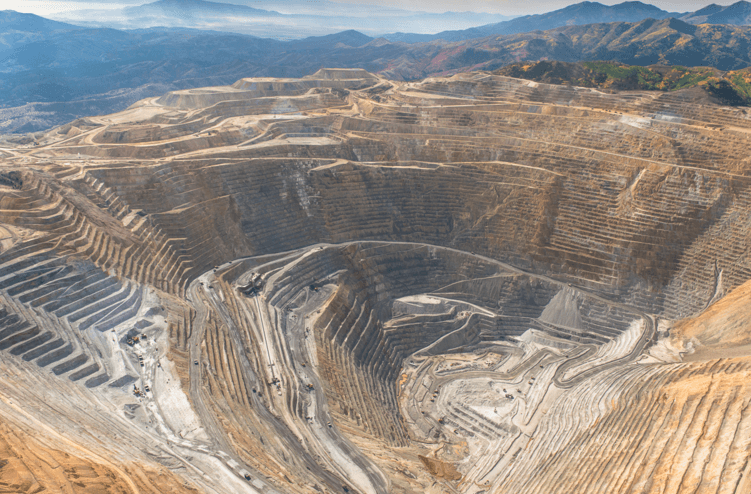
The ore body of Bingham is 2.8 km long and the pit 3.5 km in diameter it’s truly a marvel of engineering but now let’s take Bingham’s footprint and the superimpose it on a plan of the Vaal reefs mined in the Witwatersrand at the same scale. The gray areas are those that have already been mined out, the orange and dark red areas are those areas of reef that have yet to be mind. You can see that we can fit approximately 10 Bingham deposits into the Vaal reefs deposit. Course of Witwatersrand deposit are only thin layers whereas Bingham deposits extends to depth.
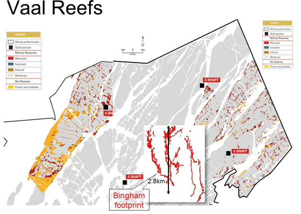
So the comparison isn’t quite fair however the Vaal reefs is only a part of Klerksdorp gold field and if we then take the Vaal reef footprints and superimpose it on the outline of the Klerksdorp gold field of the same scale we begin to see the real extent of the mineralization.
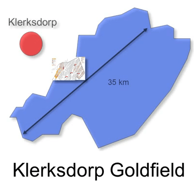
The Klerksdorp gold field is 35 km long and 20 km wide but the Klerksdorp gold field is only a part of the Witwatersrand gold system and if we were to superimpose the gold field on a geology map of the entire Klerksdorp we can see that it’s just one of several gold fields marked in blue along the rim of the Witwatersrand basin.

The other goldfields are Welkom in the Southwest, Carletonville, Johannesburg the site of George Harrison’s discovery East Rand gold fields and the Evander gold field in the extreme east. The Carletonville in Johannesburg and East Rand gold fields are basically contiguous with mineralization extending virtually continuously over a strike length of 150 km.
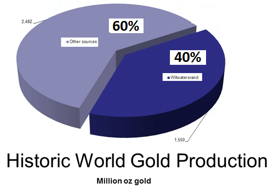
The Witwatersrand deposits have produced almost 40% of all the gold produced on earth since beginning of time over 1.5 billion with a B ounces that’s the equivalent of 305 million ounce deposits if there’s one area of agreement on the Witwatersrand gold deposits is that they are truly world class solid gold elephants.
But now we come to the genesis of the Witwatersrand gold deposits and that is marred in disagreement and had has been ever since they were first discovered 125 years ago. The genesis of these deposits is one of the biggest controversies ever in ore deposit geology with two camps; the paleopterous and the epigenesist shooting at each other from their trenches and few people risking venturing out into no man’s land between them. Before we look at the two opposing theories let’s look at what is agreed upon by both camps.

The rocks of the Witwatersrand are between 2.9 and 2.72 billion years old that puts them at the tail end of the Archean even though the style of the basin is more like of a protozoic sedimentary basin. This end of Archean age means of the Witwatersrand being deposited at that time when large proportion of the earth’s green stone belts were also being deposited. The Witwatersrand super group is sandwich between the underlying basement and Dominion group and the overlying ventersdorp mafic volcanics and Transvaal groups.
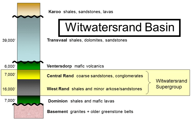
So the history can be interpreted as follows; formation of an early granite green stone terrain similar in parts of the Western Australia, Zimbabwe and Canadian cratons. A period of deformation, uplift and erosion to develop and unconformity, extension and rifting to form the new Dominion group basin, submarine basils erupted from the faults and the basin was then partly filled with fine audilacious sediments washed in from either side for up to a maximum thickness of 7000 feet. Another period of rifting deepened that basin further allowing 16,000 feet of mixed shales and arc hoses the so-called West Rand group to be deposited. Towards the end of this phase of sedimentation the basin was filled allowing occasional development of shallow water sediments such as conglomerates. At the end of the West Rand group sedimentation there was thrusting from the northwest that uplifted the basement to produce highland around the North and West margins of the basin. Erosion of these highlands led to the deposition of 7000 feet of the Central Rand group and as you will see the Central Rand group is central to the story.

Let’s run through a conceptual section across the basin. You can see the Dominion group in green being deposited underwater on the pink basement followed by the West Rand group in gray and then the development thrust from the Northwest pushing up the basement and some of the West Rand sediments to form a range of mountains near the shoreline as up lift push-up those Highlands the basement was eroded into the basin forming the course Central Rand group. These sediments were laid down in channels just above sea level or in shallow water conditions. The dominant quartz are actually surprisingly little feldspar preserved from the granites that were eroded into it and the sediment varies from fine sand stones to coarse conglomerates. With the conglomerates forming Fluvial fans around the miles of the rivers.

The out crop conglomerate that Harrison stumbled upon that fateful Sunday morning is one of these. Here is a planned view of this process with the outline of the West rand group sediments in beige. Firstly the thrusting from the northwest that forms and arc of thrust along the margin of the basin. The erosion of the highlands and the deposition of the sand stones of the yellow Central Rand group. This is an iterative process with numerous movements of the thrust and periods of uplift leading to deposition of sand stone and conglomerate. The conglomerates were formed fluvial fans along the mounds of the eroded rivers where they were subject to wave action along the shore which winnowed defines leaving the lenses of coarse clean pebbles. The sand tones and conglomerates of the Central Rand group barely had time to settle before the compression and the resulting thrusting suddenly stopped and the region went into very rapid extension again forming rifts into which some 6000 feet of assaulted volcanics poured to form the Ventersdorp group and completely burying the Central Rand sandstones and spreading out well beyond the edge of the original basin. This is a very dramatic event and happened in an incredibly short period of time. Back to our section; there are the Ventersdorp lavas being laid down there was a short break in activity following the deposition of the Ventersdorp lavas which allowed a minor amount of erosion to take place before the area began to subside under the weight of the sediments and volcanics. The sea once again invaded and deposition of the 40,000 foot thick Transvaal super group sediments began.

Later there was renewed thrusting from the Northwest.
Some of the thrusting was along old thrust and some along newly developed structures. That folding was followed by another very long period of erosion that stripped off most of the Transvaal sediments and then more recently by the deposition of the Karoo sequence and then yet another long period of erosion resulting in the landscape we see today.

So a lot has happened in this part of the world in the last 3 billion years but you’re probably saying by now this is all very interesting but; what about the gold?

Where does that fit into the story? Well if we take a look at how the gold is distributed within this stratigraphic column we see that 95% of the gold is mined, as come from the Central Rand group and more than 90% of that gold is hosted in just a few thin conglomerate units in the orange fans on the map and most of these mineralized conglomerate beds are only 20 to 30 cm or 8 to 12 inches thick. A truly remarkable concentration of gold.
At this point I’d like to take a short detour to show just how close the mining industry came to never discovering the Witwatersrand gold fields. As you can see on the map the economically mineralized gold fields in blue around the margins of the basin make up only a small percentage of the total area of these Witwatersrand basins which is the yellows and beiges. Moreover the vast majority of the fixed basin is covered by a thick sequence of younger Transvaal or Karoo sediments and does not out crop only three small nail pairings of fixed rocks actually out crop and only one of those coincides with the mineralized portion of the stratigraphy. If the erosion level were just a few hundred meters higher that small patch of mineralized rock would still be buried and the Witwatersrand gold fields would not have been discovered. The economic engine that drove the subcontinent for over hundred years will be just up a bare ridge overlooking openveld and being farmed by some old Africana in the Transvaal Republic.

But now let’s look in more details where the gold mines within those conglomerates. The bulk of the pebbles and sand grains in the conglomerates were derived from erosion of whites or gray cortsvanes and the most of the gold occurs as grains or fillings of fine fractures both between the grains and crosscutting the pebbles although the ore looks flashy in hand specimen rich in shiny yellow pyrite the gold itself is generally fine and you don’t often see it with the naked eye. Under the microscope most of the gold grains are fairly angular rather than rounded.
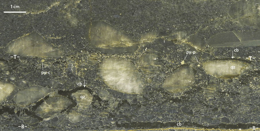
One exception to this pattern is the so-called carbon leader which is a narrow seam of bedding parallel carbon with exceptionally high gold grades. The gold is often visible in this unit and the carbon leader may also contain high uranium values which can be economically extracted.
There’s no major controversies so far both camps agreed broadly on the stratigraphy, the tectonics and deformation and the distribution of gold in Central Rand. So where is the controversy? Simply put it’s about how the gold got there? That controversy has raged virtually since the gold was first discovered in 1882 a period of over 125 years as I mentioned there are two main schools of thought; those that think the mineralization is a fluvial placid deposit somewhat modified placer metamorphism and those that believe that the mineralization was introduced by hydrothermal solutions epigenetically i.e. sometime after the deposition of the host rocks. As you would imagine both theories have good evidence both for and against them. As you saw earlier the Witwatersrand gold is generally in the Central Rand group the youngest part of the pits, The Central Rand group was deposit during the biggest pulse of gold mineralization on in greenstone belts around the world. Both theories hold that there is a connection of some sort between the Witwatersrand gold and greenstone belt mineralization but the nature of that connection is where they differ.
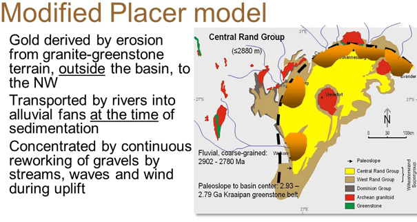
The modified placer model calls on the erosion of an older mineralized greenstone of the terrain to the northwest of the basin as a source of a fluvial gold washed down reverse and into the fluvial fans around the basin margin. When a fine silky portion of the segment was winnowed out and removed by wave action and winds even the heavy gold and coarse or well-rounded cortsvanes pebbles concentrated along the ancient shoreline. Long after burial metamorphism and deformation re-mobilized some of the gold’s into cracks in the rock. The carbon rich carbon leader is explained as being an old mat that tracks the fluvial gold that was washing over it and was subsequently metamorphism graphite it’s as simple and easily envisaged model. What’s the evidence supporting that modified placid model?
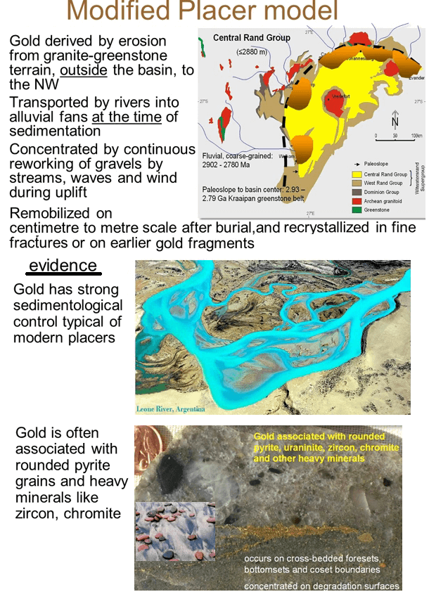
Firstly the gold has a strong spacial association with well sorted, clean pebbly conglomerates typical of those found in modern placid deposits. The gold is often channelized as in modern placid deposit. Additionally it is often associated with other heavy minerals such as water rounded zircons and chromite like those you see on modern beaches. Rounded pyrite grains are common in the Witwatersrand but they are seldom seen in modern placer. This is explained by the low levels of atmospheric oxygen in the Archean.
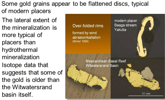
A few of the gold grains appeared to have been flatten with curled edges as they are in the modern-day placer as is often see in the Witwatersrand gold mineralization is generally very laterally extensive and widely consistent in grade and thickness much more so than most hydrothermal deposits would be. Finally to summarize the topic data which indicates that at least a small portion of the gold is older than the Witwatersrand basin sediments and so it must have been introduced from the erosion of older rocks outside of the basin.
What about the opposing hydrothermal model?
How do the components of that theory explain the concentration of gold? They believe that the vast majority of the gold did not wash into the basin from the northwest but that it came from a deep source beneath the Central Rand being epigenetic was introduced or concentrated long after the deposition of the host sediments either during the metamorphism of the Witwatersrand sediments themselves or from a magmatic source at depth or around the rim. As in the greenstone gold deposits they postulate that the gold was transported as a bisulfide complex in hot hydrothermal solutions. They explained the special relationship with the conglomerates as being due to the highly porous nature of the conglomerates which acted for the hydrothermal fluids.
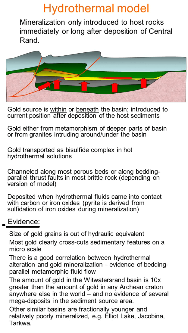
As indicated the greenstone mineralization the gold would’ve dropped out a solution when the reductants in the form of either carbon or pyrite was encountered. So if you return to our cartoon cross section of the Witwatersrand basin to summarize the hydrothermal model the gold was postulated to have been introduced after the deposition of the host rocks either from the deeper parts of the basin or along the thrusts faults. In either case the fluids were channeled along the most porous beds in the stratigraphy, the common conglomerates and the coarser sand stones of the Central Rand group. What evidence supports the hydrothermal model? Firstly although the gold is generally found in the coarse fraction of modern placids the size of gold grains in the Witwatersrand suggest that they should be associated with their hydraulic equivalents which would be coarse sand stones rather than the conglomerates that we find them in suggesting that the gold was not deposited as grains carried by running water. In addition the majority of the gold cross cut sedimentary features also there is a good spacial correlation between the observed fillic or hydrothermal alteration which even the placer concedes as hydrothermal and the gold. Most critically however the amount of gold in the Witwatersrand basin is in order of magnitude greater than the amount of gold in any Archean cratons anywhere else in the world. This makes it difficult to call upon the erosion of a typical archaen terrain to the northwest to supply that amount of gold. If it didn’t come from there they argue it must have come from below. Finally in other sedimentary basins where there is similar sources of sediment such as Elliot Lake in Canada, Jacobina in Brazil or The Tarkwa in West Africa they don’t have nearly the same amount of gold mineralization but then they are fractionally under.
So let’s summarize the situation, there’s been a historical bias towards the easily understood modified placer model that there has been research into the hydrothermal model in recent years. Sedimentalogical analysis has proofed very successful indicating and predicting mineralization which lends credence to the placer theory.
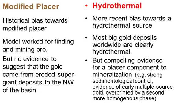
However there are very large no Witwatersrand deposits. Most very large non Witwatersrand deposits are demonstrably hydrothermal in nature. There is absolutely no evidence to show that the terrain to the northwest hosted any outrageously extensive greenstone gold mineralization as a possible source for the placers. Working against the hydro thermals is evidence that some gold predates the Witwatersrand basin. So we have two entrenched opposing camps with no willingness to compromise.
As a compromised model applying our recently improved understanding of gold mineralization processes and using elements borrowed from both viewpoints makes the most logical sense. To my mind there are three rarely critical facts that have to be accounted for in any model. Firstly there is too much gold in the Witwatersrand basin to call on an eroded greenstone terrain as a sole source.
Secondly the central Rand group was deposited at the same time as one of the two biggest pulses of hydrothermal gold mineralization in the earth’s history the other was in the tertiary. In part 4 of the Ore Deposits Geology Course series I described a working theory whereby the sudden onset of crustal shortening at this time in the earth’s history resulted in massive partial melting of the deep crust under the cratons.
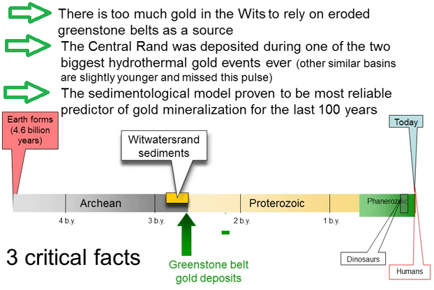
This melt provided the source of gold for the greenstone belt deposits. Other similar basins such as Elliot Lake and Jacobina and Tarkwa are fractionally younger and they would’ve missed out on this rush of gold the from the lower earth crust.
The third critical fact is that the sedimentalogical model has proven to be the most reliable predictor of gold mineralization in the mines of the last 100 years. Now because of the inability of any greenstone terrain to supply enough eroded gold to produce the volume found in the Witwatersrand I’m forced to conclude that the gold was originally introduced hydrothermally either from below or laterally and because the timing is synchronous with the greenstone belt mineralization elsewhere in the world the path of least astonishment is that the mineralizing fluids were probably similar in nature and derived from the same deep crustal source area as the fluids that mineralized greenstone belts all over the world.
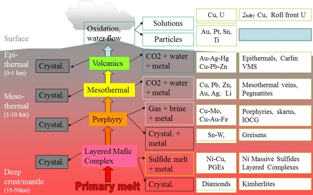
We are dealing with a source fluid that is being generated by partial melting of deep crustal material with the gold being concentrated as the belt rises and cools in the same way as the greenstone mesothermal gold. However whereas the fluids in the greenstone environment encountered either relatively impermeable volcanics are metamorphism sediments that force the fluid to travel along tight structures in the case of the Witwatersrand the fluids encountered beautifully permeable and continuous conglomerates and sand stones allowing them to flow freely almost horizontally and deposit gold widely over large areas before reaching the surface as epithermals. We had in effect a series of very large mesothermal and epithermal systems. The onset of thrusting to the northwest of Witwatersrand basin coincided with the onset of major thrusting in many other parts of the earth and also with the start of the deposition of the Central Rand group sediments.

The thrusting thickened the crust causing partial melting of deepest portions. That melt rose up through the crust and as it cooled and crystallized at depth produced the gold rich hydrothermal fluid. The thrust fluid faults provided the best plumbing to get the melt and the fluids from the deep crust through the basement and into the Witwatersrand basin.

Once the fluids reached the permeable Central Rand group they acted like any groundwater and floated down the hydro logical gradient following the most permeable beds and the most permeable beds with the newly deposited conglomerate.
As we can see from this table of permeability shales like those in the underlying West Rand group have a hydraulic conductivity of 10 to the -4. Sandstones like the majority of the Central Rand have a permeability of about 10 to the -1 but clean gravels similar to the Witwatersrand conglomerates have a hydraulic conductivity of 10 to the +1.

In other words conglomerates are a 100 times as permeable as the surrounding sand stones and 10,000 times as permeable as the shales. So we know were the fluids would have gone. As the pressure in the rising fluids dropped they boiled and cooled and precipitating gold out of solution just like in the deeper parts of modern day epithermal deposits. Eventually the gold charged fluids reached the surface either via the day lighting thrust faults or where the conglomerates horizons came to surface forming and arc of epithermal systems around the rim of the basin. River erosion and wave action continually rework those epithermal deposits and concentrated the gold in second or third generation conglomerate deposits just as the placers described.

A modern example of this can be seen on the Italian coast where small epithermal deposit is being eroded and depositing gold on the adjacent beach. I was initially concerned that the Central Rand sediments don’t have class of banded epithermal style vanes or center but since then I’ve walked downstream from a number of eroding epithermal deposits and found that epithermal veins don’t transport at all well and they are rapidly reduced to fine salt. Then much later after the Central Rand group have been buried by the Ventersdorp lavas and Transvaal sediments the mineralization was metamorphism and minor re-Distribution of the gold occurred as the modified placer is called for. Now with this hybrid model the difficulty of finding a source for the gold in the surrounding greenstone terrain is removed and the method of deposition of the gold in the Central Rand group is resolved while still providing an explanation for the stratigraphic control to the mineralization that is so well proven in the Witwatersrand mine. In the same way as epithermals and porphyry are clearly genetically linked in the Witwatersrand deposits I suggest that we’re looking at hybrid deposits containing elements not only of mesothermal and epithermal deposits but also of placer deposits.
Witwatersrand gold reefs Mining Method:
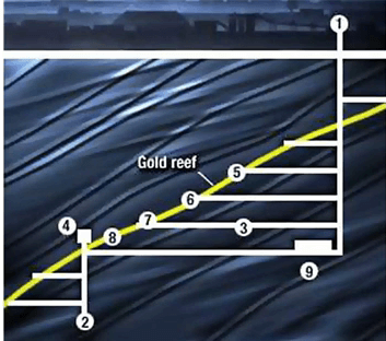
As I mentioned earlier the gold is predominantly hosted in 20 to 30 cm thick conglomerate units that dip towards the center of the basin at 20 to 42° the reefs obviously cannot be mined to this narrow width and most stopes are just over 1 m in height which means that there are significant dilution of the ore by waste but importantly it means that a high degree of manual labor is required which is costly both in monetary and social terms.
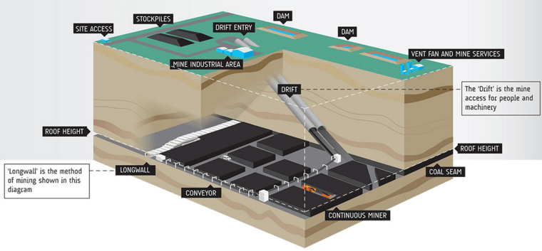
The usual mining method used is long wall mining which is similar to the method used in coal mining. Research has been going on for many years to try to automate the mining but results so far have been very limited. The ore is simply too hard for coal cutters and the need for blasting prevents a continuous mining approach.

An exception to this narrow stope mining is that gold fields South Deep deposit where a series of reefs converge and a much thicker package up to 30 m are somewhat lower in grade allow us mechanize cratons fill stoping. The Witwatersrand mines are the deepest in the world around 40,000 m or 13,000 feet shaft sinking to service these depths is very expensive and time-consuming the twin shafts of South Deep took nine years to sink and cost $600 million.
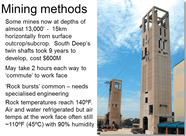
Today the cost would probably be two or three times that also because of the dip some of the deeper mines are now mining 15 km down dip from the original out crop and the daily commute from surface to the work phase may take two hours each way this obviously leads to huge inefficiencies and discomfort for the labor force. The extreme depths lead to great operational difficulties with pressure burst and rock temperatures 140 degrees Fahrenheit or 660 degrees centigrade. So the specialized engineering techniques and refrigeration of ventilation air and water is necessary. In spite of the refrigeration work conditions are extremely tough. Lately there’s been labor unrest in South Africa with minors protesting their low pay for the very hard work unfortunately the mines are operating with an increasingly small margin and a when forced to raise salaries they have no choice but to close down unprofitable shafts that has led to more unrest and threat of nationalization of the mines by the more extreme members of the ruling party. Faced with the risk of nationalization most companies come to conclusion that they cannot commit to the cost and the time involved in sinking any new shafts. The South African gold and platinum industries as well trapped.
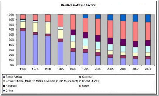
The future of the Witwatersrand gold mines. This financial, social and political squeeze has been going on for many years now and this is reflected in South Africa steadily shrinking share of the world gold production from a dominant 70% in the 1960s down to just 7% in 2011. So do the South African Witwatersrand gold fields have a future? South Africa still has about 1.2 billion ounces in reserves almost 50% of the world’s reserves however a combination of factors is steadily increasing costs and risks so that the vast majority of these reserves are likely to become uneconomical and figuratively evaporate. These factors include ever deeper mining with associated rising costs and technical risks, the union driven workforce that has shown that it can bring the industry to a halt in support of wage claims, a restive and underprivileged national population which is being told by certain politicians that nationalization of the mines will benefit them, power shortages that will continue to plague this country and the mines for the next few years before additional capacity can be brought online. As a result production is likely to continue to slide in a significant number of shafts and mines will continue to shut down over the next few years. My inescapable conclusion is that although the Witwatersrand is the biggest elephants of them all its moving inexorably towards extinction unless; unless a new remote mining technologies can be developed to allow low-cost automated mining of very narrow stopes. Development of these technologies would go a long way towards allowing continued mining of the existing reserves. I have great faith that the lure of that much gold will eventually lead to a technological breakthrough that would in turn solve a lot of the social issues. There would be far fewer people working underground, allowing less chance of accidents and better working conditions for example the ability to work from air-conditioned operating stations. The political issue remains the wild card.
The Witwatersrand has been the biggest producer of gold in the world by far. In spite of a lot of effort around the world to find other Witwatersrand this hasn’t happened and I doubt whether there is one. The origin of the gold is controversial with two schools of thought, the modified placer origin and the epigenetic hydrothermal origin. I personally believe that the logic dictates that the truth lies in a combination of both processes. There are huge gold reserves and resources still remaining almost half of the world’s gold reserve still lie in mine in the Witwatersrand basin but these are generally too deep for juniors to mine or explore for. They are the domain of the mining majors. In recent years we’ve seen several smaller companies try to mine or explore for Witwatersrand deposits but ending up bankrupt and stepping away from the environment. Juniors are out of their depth in the Witwatersrand both literally and metaphorically. The Witwatersrand basin contribution to world gold production will continue wane due to both macro and micro economic factors with the decline of this huge source of gold production and even with China’s gold production accelerating rapidly I believe that world peak gold has past. I believe that new technologies will be found to allow remote mechanized mining but whether this will reverse the trend remains to be seen that is ultimately in the hands of politicians.
