Table of Contents
- Outfitting for a Gold Prospecting Trip in Quebec
- Transportation
- Routes to the Quebec Gold-Belt
- A Brief Synopsis of the Mining Laws of Quebec
- General Geology of the Quebec Gold-Area
- Gold Prospecting
- Scientific Prospecting Methods
- Field Tests for Determining the Approximate Value of Gold Ores
- Locating a Claim
- Prospecting and Exploring a Claim
- Underground Exploration by Diamond-Drilling
- Conclusion
The prosperity of any nation depends, to a large extent, on its natural resources such as oil, coal, metal, timber, water-power, and fertile soil. Each one of these resources forms the basis of a huge industry. The mining and smelting industry ranks among the first since it paves the way for a number of other industries. The mines and smelters provide a market for electric power, coal, timber, and agricultural products: other industries in turn provide a market for metals and non-metals.
The real pioneering, however, is done by the prospector who goes into the wilderness to search for the ores from which the metals are to be extracted for the use of men. Prospecting is an interesting and fascinating occupation. There are many difficulties and hardships in the way but the lure of gold and the vision of finding an outcrop that may develop into a large bank account, within a reasonably short time, will urge the prospector forward.
Thus, on the outskirts of this northern hemisphere hundreds of prospectors are searching and toiling and of whom nothing is known or heard until they reach civilization and announce a new discovery. Then a mad rush takes place and everybody who can afford to go will take a gamblers chance and plant stakes in the neighbourhood of the new discovery, or wherever an outcrop of mineralized rock can be found, with the hope of winning a fortune.
Such a stampede started about two years ago in Rouyn township, Quebec, when rumors of new gold discoveries became known and interest in this district has been stimulated by later discoveries in Rouyn and in the surrounding townships.
Outfitting for a Gold Prospecting Trip in Quebec
A prospector’s outfit should be as complete as possible, yet it should not contain anything but the most essential. Unnecessary articles are a continuous burden when portaging while a shortage of essentials, such as a compass or a mosquito-bar, may cause a great deal of annoyance and inconvenience.
It is a good policy for two prospectors to join forces, as that makes work easier, and the judgment of two men is often better than that of one; moreover, two men can cover twice as much ground in the same time, and do more than twice as much work. The first part of a prospector’s outfit, then, is a congenial partner.
As regards the outfit, the following is convenient for the summer months, from May to the beginning of October.
Tools:
One pick……………………………………………………………………………………..$ 1.75
One shovel…………………………………………………………………………………….1.25
One Hudson Bay axe………………………………………………………………………1.25
One geologist’s pick……………………………………………………………………….1.50
One long-handled striking hammer………………………………………………..1.00
One blacksmith hammer……………………………………………………………….1.25
One gold pan………………………………………………………………………………..1.50
One mortar and pestel………………………………………………………………….1.50
Three drills, inch steel, of different length……………………………………..4.00
Dynamite, fuse, and detonators…………………………………………………..12.00
Total cost of tools……………………………………………………………………..$27.00
Food: — This list is compiled from the average amount of food consumed by different prospecting and survey parties and reducing this amount to a per man-day basis.
Another very desirable item that should be included, especially when prospecting in Quebec, is one quart of fly-oil per man. It may be prepared as follows:
16 oz. olive oil
½ oz. Friar’s balsam
½ oz. oil of peppermint
1 oz. oil of citronella
An alternative preparation is:
1 pt. pine tar
1 pt. olive oil
1 oz. carbolic acid
1 oz. oil of citronella
The cost per quart is approximately $1.50.
The prices mentioned are about the average and allowance must be made whether goods are bought from a wholesaler or retailer. The total cost of a complete prospector’s outfit should, therefore, be in the neighbourhood of $200, not including food.
The items listed above are essential for equipment per man. If, however, two prospectors enter into partnership, many of the articles can be used conjointly and the individual cost of outfitting can be reduced considerably.
Transportation
Travelling to and in the Quebec gold-belt is comparatively easy, since there are numerous lakes and rivers. Motor boats carrying supplies to central points in the district operate on some of the main water routes. From there on the canoe is the most suitable means of handling the outfit, using the water route wherever possible and packing across portages.
Another means of transportation is by aeroplane. The Laurentide Air Service Limited operated several flying-boats during the past summer, between Haileybury and various points in the gold-belt, carrying freight and passengers. This company also operated during the past winter from a base at Larder Lake.
A third means of transportation, during the winter months, is by sleighs and horses over the winter roads.
Routes to the Quebec Gold-Belt
Perhaps the most important is the air route which needs little description. During the summer months the planes operated between the base at Haileybury, Ont., and Angliers, Rouyn and lake Fortune, P.Q., also to other points on special occasions. The time of flight between Haileybury and lake Fortune is 45 minutes, a distance of about 60 miles. During the winter months the aeroplane base was at Larder Lake, since the Temiskaming and Northern Ontario Railway has now completed its branch line to this point. The distance from the east end of Larder lake to lake Fortune is 17 miles and from lake Fortune to Rouyn 14 miles.
Summer routes: — From the Canadian National railway the gold area can be reached in two days by canoe. Starting from La Sarre, the route follows La Sarre river for eight miles then crosses lake Abitibi and up Abitibi river to Duparquet lake; then up Kanasuta river to Dasserat lake, Ogima lake and Summit lake from which a good wagon-road leads to lake Fortune, and a trail continues to Rouyn and into Joannes township. There are only seven portages on this route, the longest being half a mile.
Another route, from the south, starts at New Liskeard, or Haileybury, on the Temiskaming and Northern Ontario railway. Large quantities of supplies can be taken over this route. Starting from New Liskeard one may travel by steamboat or motor car to North Temiskaming, from which place a fairly good road (improved last summer) runs north to the foot of Opasatika lake, a distance of 28 miles. Motor boats convey passengers and supplies 20 miles to the head of Opasatika lake, where the same road (mentioned in the preceding paragraph) to Rouyn is reached.
An all-water route starts from Gillies Depot on Quinze lake, which may be reached in two hours by motor car from Ville Marie. This route follows the east arm of Quinze lake, through lake Expanse, up the Ottawa and Kinojevis rivers, through Kinojevis lake to Routhier lake and Rouyn lake.
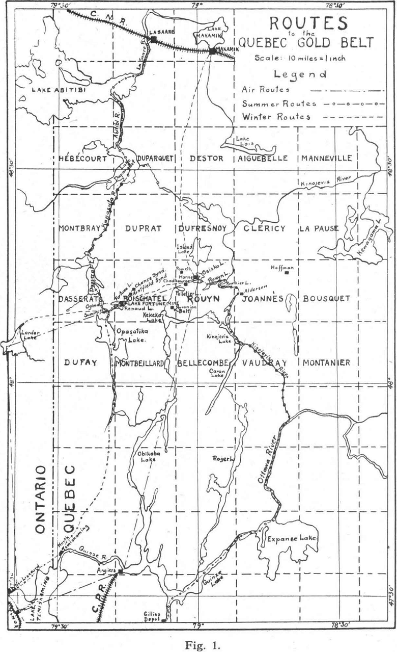
From Rouyn lake there is a portage three-quarters of a mile long to Osisko lake. This route is about 75 miles in length, but has the advantage of being an all-water route, except for the one portage mentioned.
Winter routes: — Since the Temiskaming and Northern Ontario Railway has completed its branch line from Swastika to Larder lake, supplies can easily be taken in from Larder during the winter months. After crossing Larder lake, a distance of 8 miles, a good winter road extends eastward for 31 miles to Rouyn via lake Fortune. This road follows roughly the survey line of the proposed extension of the branch line of the Temiskaming and Northern Ontario railway from Larder lake to Rouyn.
Another winter route, which was used for the first time last winter, runs due south to Rouyn from Makamik, a town on the Canadian National railway. The distance is about 36 miles. The passenger rate is $5 per trip, and the freight rates vary between 1.25 and 1.75 cents per pound. Figure 1 shows the different routes.
A Brief Synopsis of the Mining Laws of Quebec
A prospector should first of all become familiar with the mining laws of the province in which he intends to prospect.
His first requirement is a miner’s license costing $10. This may be obtained from any mining recorder or from the Department of Mines at the city of Quebec, and entitles the prospector to search for mineral and locate claims on crown lands — where the mineral rights have been reserved by the crown. The area of a claim is 40 acres, or 20 chains square. In any one year five claims may be staked, but the total area must not exceed 200 acres. The assessment work required is 25 days for each 40 acre claim, to be completed within six months from the date of staking; but the months of January, February and March are not counted in this six months period. The assessment work may consist of stripping, trenching, sinking or diamond-drilling. Diamond-drilling is counted as two days assessment work for each foot of rock drilled. An official survey of a claim is counted as assessment work, but the maximum allowance for a survey is 25 days. If a claim-holder wishes to maintain his rights he must, of course, possess a miner’s license. In addition to this an annual rental of 50 cents per acre must be paid. If for any reason, acceptable to the Minister, the assessment work can not be performed an additional rental of $1. per acre may be paid in lieu of assessment work. A mining concession or title may be obtained at any time after the claim is located. The cost is $5. per acre for the superior metals and minerals, such as gold and silver, and $3. per acre for the inferior medals and minerals.
General Geology of the Quebec Gold-Area
The oldest rocks in this area are the Keewatin lavas, consisting chiefly of basalts, rhyolites, and tuffs. Separating them from the Timiskaming sediments is a great unconformity. These strata were subjected to much folding and metamorphism and in some places have been completely overturned. This crustal movement was accompanied by many intrusions, chiefly of basic rocks, in the shape of sills and dykes. The most important of these are the syenite porphyries which are supposed to be the source of gold in this area. After the period of intrusion ceased, another series of sediments (the Cobalt series) which covers only a small area of the district, was laid down. Later, during the glacial period, a large part of the gold-area was covered with morainic material, gravel, sand, and clay.
There are two belts of Timiskaming sediments in this area — extensions of the same sediments which are found in the Kirkland lake and Porcupine gold areas. The southern belt passes through Boischatel, Rouyn and eastern townships, while the northern belt extends through Duparquet and Destor townships. It is along the contacts of these sediments that the syenite porphyries are found. There are also scattered dykes of this porphyry throughout the Keewatin lavas.
The sediments of the Cobalt series are of little economic importance and are easily distinguished from the Timiskaming sediments, which are highly metamorphosed and sheared. The pebbles in the Timiskaming sediments are lenticular in shape and the beds are tilted at an angle of 45 to 60 degrees,
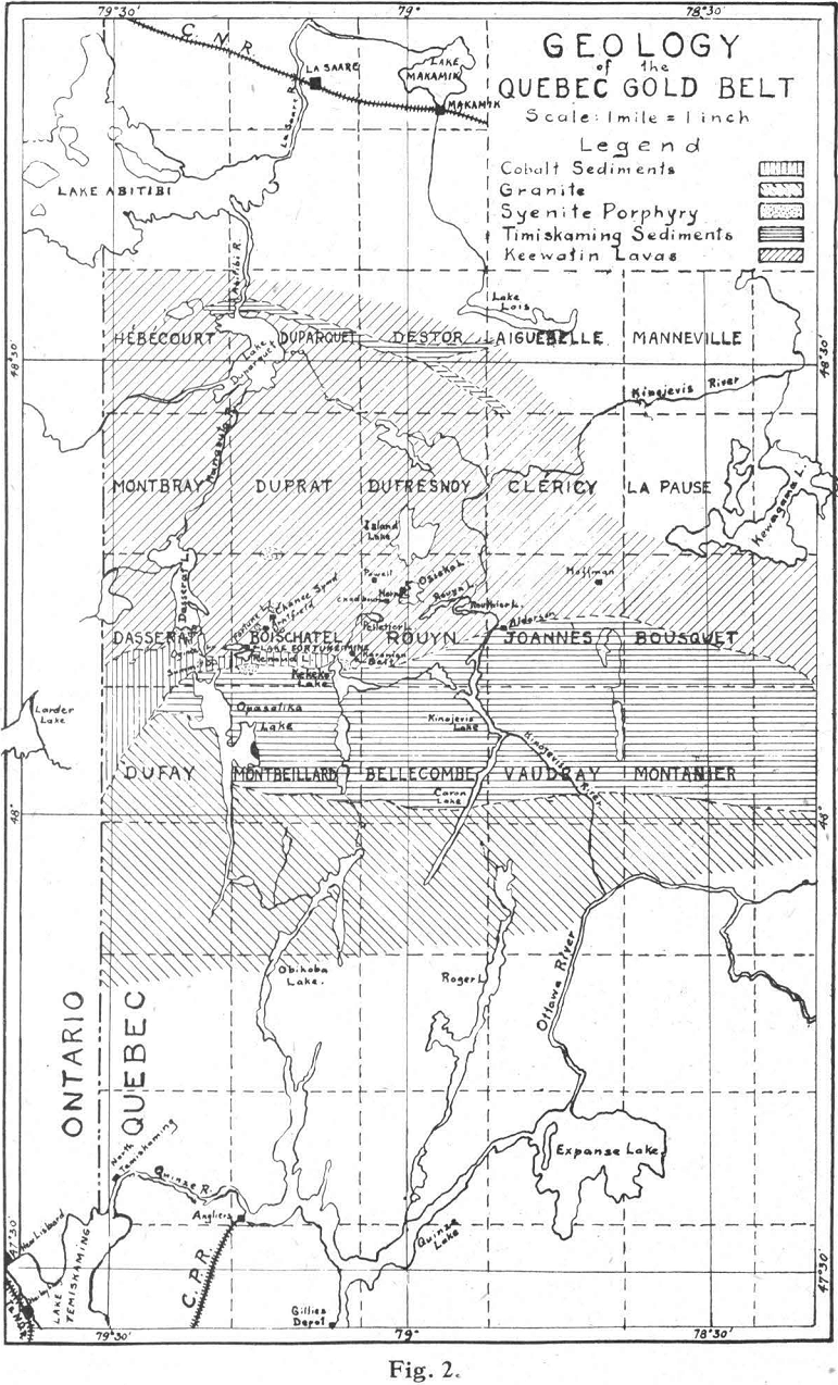
whereas the sediments of the Cobalt series are unaltered and the beds lie practically in a horizontal position. A sketch map (Fig. 2) shows the general geological features of this area.
Gold Prospecting
Prospecting is searching for ore that is indicated by surface phenomena. One of the chief requisites for successful prospecting is good eyesight, so that any unusual condition or change in the ground may be instantly noted.
In the Quebec gold-belt the prospector is largely guided by geology. Since most of the discoveries made in this area are closely associated with syenite porphyry, he naturally looks for such rocks. Many prospectors also observe the ground closely for quartz. They sound the rock as they go along by striking their pick through the moss. With some practice, quartz can easily be distinguished from slightly decomposed country rock by the sound and feel of it when struck with a pick.
When float is found it should be noted whether or not it bears any relation to the local geology. This may sometimes be determined by the shape of the float, whether angular or rounded and water worn. It must be remembered that in the Quebec gold-area glaciers have carried fragments of rock for hundreds of miles and dropped them at random. Tracing float by panning or trenching has not been successful in this district, since most of the overburden is of glacial origin: the prospector must therefore rely largely on his own ingenuity in locating its source.
Shear-zones and contacts in this area are of considerable interest to the prospector. When such a zone is found, the strike is roughly determined and then followed by zig-zagging across it. If an outcrop shows any signs of shearing, it is carefully examined for minerals. Partly-decomposed rock stained with iron rust is panned for free gold. A coarse wire screen, about 4- or 6-mesh, may be used to speed up the work, washing the fine material into the pan and discarding the coarse particles remaining on the screen.
Scientific Prospecting Methods
In recent years electrical methods of prospecting have been developed. The general principle on which such methods are based is the fact that the electrical conductivity of the rocks and soil of the earth’s surface varies considerably. Minerals, especially metallic sulphides, are 1000 to 10,000 times better conductors than ordinary rocks, and a rock of one structure may conduct an electric current ten times better than an adjoining rock.
Minerals are divided into two classes of conductors, ‘metallic’ and ‘electrolytic’. Nearly all metallic sulphides conduct electricity in the same way that metals do, that is, without the displacement of ions; these are called ‘metallic conductors’. The other minerals, either ores or barren rocks, are more or less perfect insulators and owe their apparent conductivity to the absorbed water which they contain; they are called ‘electrolytic conductors’. Examples of such are zinc blende, stibnite, and most oxides and carbonates. The quantity and composition of the absorbed water controls the phenomenon. Loose earth and superficial clay should, in general, because of their higher water content, be better conductors than deep-seated rocks.
In applying these principles to prospecting, it is possible to detect the presence of certain types of orebodies. Three distinct methods have been worked out recently.
The Schlumberger method of electrical prospecting: — This method has recently been developed by Professor Schlumberger of the Ecole des Mines, Paris. It takes advantage of the fact that electrical currents are generated within the mass of certain types of orebodies. An external current is not introduced into the circuit. The flow of electricity in orebodies is probably due to the activity of dissimilar waters at various points. Surface water containing oxygen in solution gives rise to an oxidizing reaction; at a greater depth, in the zone of reduction, a reducing reaction takes place. Thus a difference in potential is set up causing a current to flow from the point of high potential to the point of low potential. While this is recognized as being true for general surface conditions the reaction is more pronounced in a mineralized zone.
The practical application and success of this method depends greatly on the accuracy with which such electric currents can be detected and measured. It is also essential that the minerals be sufficiently concentrated to provide practically a continuous path for the currents; and that the deposit be at least within 200 to 300 feet of the surface for these currents to be detected apart from ordinary earth-currents.
The apparatus consists of two non-polarizing electrodes and a potentiometer, by means of which the direction of the current can be determined. The electrodes are touched to the ground at various places until a point is located into which the current seems to flow from all directions. This point may be above the apex of a mineral deposit. Using this point as a centre, points of equal potential difference are found by means of the electrodes and the potentiometer. These points are plotted and joined by lines which should close about the centre. This line is called an equipotential curve and the area inclosed by it should be nearly elliptical in shape. The major axis of this figure should be parallel with the strike of the mineral deposit. Thus the strike of a deposit may be determined.
Experiments by this method have been carried out in the Flin Flon district and at lake Athapapuskow in Manitoba, in the Porcupine district in Ontario, and elsewhere in Canada. The results have been reasonably successful. The first actual Canadian discovery of a metalliferous deposit by this method was made at lake Athapapuskow, where trenches were dug and a small sulphide vein was uncovered, after the electrical observations were plotted.
This method was tried at one of the properties in Rouyn last summer and is the only electrical prospecting done in this area. The results have not yet been published.
The Lundberg-Nathorst method of electrical prospecting: — The principal feature of this method is that an electric current is passed through the ground between two points, and the nature of the electrical field thus produced is studied by measuring the difference of potential between a number of points on the surface. The points are plotted and those of equal potential are joined and an equipotential curve is produced. A large number of such lines or curves are drawn and the results are interpreted by the shape of them. Good conductors tend to thrust these lines apart, poor conductors seem to cause constriction.
A small generator is used which provides a single-phase alternating current with constant frequency. The electrodes, which consist of wires, are connected to the poles of the generator and spaced 100 to 1000 metres apart, where they are connected to the ground. The distance between them is varied in accordance with the depth at which it is desired to investigate.
In tracing the equipotential curves a movable searching-circuit is used, consisting of two metal rods fitted with insulated handles and connected to an insulated line attached to a telephone. Points of equal potential are located by placing one rod on the ground and then searching with the other rod for a point on the ground at which no sound is detected by the telephone — the two points are then at the same potential. If, however, the two points are not of equal potential, a sound, corresponding to the frequency of the generator, can be detected by the telephone. This sound can be strengthened by the use of an amplifier.
The Lindblad-Sundberg-Vos methods of electro-magnetic prospecting: — These methods were devised in Sweden and are in some respects similar to the equipotential methods previously described.
An alternating electric current is passed between two points in the ground. If there is an orebody between the two points, the main part of the current will find its way through it. This current is strengthened by induced currents from the generator lines to the points fixed in the ground. The position of an orebody can then be determined by an investigation of the distribution of the current between the two points. This is done by determining the direction and strength of the electromagnetic field generated by the currents. The electromagnetic field at the surface is strongest vertically above the ore, and its direction is at right angles to the strike of the orebody. The measurements are made by means of a coil connected to an audion-voltmeter. An electromotive force is induced in the coil, by the electromagnetic field, which is measured by the audion-voltmeter. These readings are proportional to the strength of the inducing electromagnetic field. “When the plane of the windings of the coil coincides with the direction of the electromagnetic field, no readings are obtained. If the coil is then turned at right angles to this direction the maximum reading is obtained, which is thus a measure of the strength of the electromagnetic field at the point in question.
These methods have been patented and are owned by a Swedish company who report their successful application in Sweden. This company has established a branch in New York known as the Swedish American Prospecting Corporation.
One of the Swedish methods of electrical prospecting was used at the Nipissing mine at Cobalt last summer. The results, however, are not as yet available for publication. The Quebec gold-area should be especially adaptable to electrical prospecting because a large part of the area is covered by post-glacial clay, deep enough to dishearten the ordinary prospector, but not too deep for the application of electrical methods. There is also a considerable area covered by swamps, which may hide some of the finest orebodies from the prospector.
Shear-zones, owing to their shattered condition, are easily eroded to a lower level than the surrounding rocks and it is quite probable that they may be found in swampy regions. Such areas are practically inaccessible by ordinary means of prospecting and, therefore, electrical prospecting, during the winter months, appears to be the only practical method of investigating these areas.
Field Tests for Determining the Approximate Value of Gold Ores
Panning for free gold may be accomplished by weighing a portion of ore, ground to 80 or 100 mesh, and concentrating the gold by panning, then weighing the colours. After some experience the prospector may be able to closely estimate the value of an ore by counting the colours. Mercury may be added to the pan to collect the gold and retorting accomplished by heating the amalgam on a shovel. Care must be taken not to inhale any of the fumes of mercury. The button of gold obtained in this way may be weighed or its value estimated.
In panning ores containing auriferous sulphides a weighed quantity of finely crushed ore is well roasted in a pan or shovel then mixed to a thick pulp and well rubbed, with the addition of mercury, in a pan or mortar. The pulp is then panned to collect the amalgam, which is treated as previously described.
Locating a Claim
Having found a vein or a mineralized zone which promises to be of value, it would be good policy to examine the surrounding area closely for similar parallel veins. The dip and strike of the vein or zone should also be determined, so that the claim may be laid out to cover as much of the mineralized area as possible.
The boundary lines of the claim should run as nearly as possible, north, south, east, and west. All posts should be squared and should not be less than four feet above the ground and be at least four inches square. A discovery post is placed at a point where the average character of the deposit is well displayed. The following inscription should be legibly written on the side of the post facing No. 1 post:
- Discovery Post.
- The name of the locator.
- The number of the locators license.
- The date of the discovery.
The No. 1 post is then placed at the north-east corner with the following inscription facing No. 2 post:
- No. 1 Post.
- The name of the locator.
- The number of his license.
- The date.
- The distance and bearing to the discovery post.
No. 2 post is placed at the south-east corner, No. 3 post at the south-west corner and No. 4 post at the north-west corner. The distance between the corner posts should be 20 chains, or 1320 feet.
The inscription on each corner post is the same as for No. 1 post, except that the number is changed and the distance and bearing of each preceding post should be indicated. The writing on No. 2 post should be facing No. 3 post, and so on.
The boundary lines between the corner posts and also the line between No. 1 post and the discovery post should then be blazed or marked so that they may be easily seen.
Should one of the corners of the claim be inaccessible, a witness post must be placed at the nearest practical point with the following inscription:
- W.P.
- Distance and direction of the true point.
- Same details as on the other posts.
After the claim is staked it must be recorded within 15 days of the date of location, and the following information supplied to the mining recorder:
- A sketch of the claim with reference to some established point or landmark.
- The number and date of the miner’s license.
- Date of location as marked on stakes.
- The number of stakes placed and the bearings and distances between them.
- The signature of the person who staked the claim.
Prospecting and Exploring a Claim
One of the first requisites in intelligently prospecting and exploring a claim should be the construction of a geological map of the surface. This map should show all the details of the geological structure, such as contacts, shear-zones, dykes, veins, dips, and strikes. There are two general methods which may be employed, the plane-table and stadia, or the tape and compass method. The choice of method depends largely on the nature of the surface to be mapped. If there is not much timber on the claim, so that a large area can be mapped by one set up, or if the area is dissected by wide streams, the plane-table and stadia method would be the quickest, cheapest, and perhaps the most accurate method to be employed. If, however, the claim is covered with much timber, and the outcrops are scattered, much time would be lost by moving and setting up the plane-table: on such ground the tape and compass method could be used more advantageously.
The plane-table and stadia method: — The instruments used consist of a plane-table, a telescopic alidade, and a stadia rod. A description of these is hardly necessary as everyone is more or less familiar with them.
The instrument is set up at a point from which as many sights as possible can be taken. If the rodman is familiar with geology only two men are required to construct a map by this method. The edge of the table is oriented magnetically by means of a compass needle in a box set flush with the table surface. The rodman then picks a point at the edge of an outcrop, the other man sights on the rod, keeping the zero of the alidade scale on the point corresponding to the location of the plane-table, he then reads the intercept between the upper and lower wires and plots the point. Other points are located similarly, the rodman following the edge of the outcrop. After the outcrop has been plotted, the rodman follows the contacts and any other important features of the outcrop, until it is mapped in detail. Then the instrument is set up at a new station, with the table again oriented magnetically. The rod is held on a known point and a sight is taken on it, with the zero of the alidade scale on the known point. Then the new station can be located on the map by scaling the distance from the known point in the proper direction. If there is any local attraction the table is oriented by setting up on a known point and sighting back on the last station. As much area as possible is covered from each station. The different formations should be coloured with crayons as the mapping progresses.
The tape and compass method: — The principal instruments used in this method consist of a 200-foot steel tape, graduated throughout in tenths of a foot, a 100-foot linen tape, graduated in tenths of a foot, and a pocket compass.
The type of compass most efficient for this work, and generally used, is a prismatic provided with sights, with the needle floated in oil. The advantage of the floated needle is that it comes to rest quickly, speeds up the work, and spares the compass-man a great deal of annoyance during the fly season. The Brunton, or ordinary surveyors compass mounted on a light tripod, may be used but neither of them is as convenient as the prismatic compass for this particular work.
The actual mapping of the surface is done by running a series of parallel lines, 200 to 300 feet apart, across the claim and approximately at right angles to the general strike of the formation. The work may be carried out by three men, two of them chaining and one putting in the geology. Notes are taken and the map is plotted from the notes. However, much greater speed can be made by a party of four, two chainmen and two geologists. In this case practically no notes are taken, the map being sketched in the field.
Assuming the general strike of the formation to be east and west, and starting at the north-east corner of the claim, (No. 1 post) the front chainman, equipped with compass, a small axe, and holding the zero end of the 200-foot steel tape attached to a strong cord and hung over his shoulders, makes a compass sight along the east boundary line of the claim to determine its magnetic bearing. He then determines the bearing of the north line. A note of this is made by the geologists who are equipped with strips of co-ordinate paper, about 6 inches wide, tacked to a narrow board 20 inches long and 6 inches wide, which is easily carried. The geologists should also be equipped with a compass, an instrument for measuring dips, and a geologist’s pick. The rear chainman is given a small axe, and the 100-foot linen tape for measuring offsets.
The front chainman then walks west along the north boundary of the claim and establishes a point 150 feet from No. 1 post where a picket is planted with the co-ordinates marked upon it. From this point a line is run parallel to the east boundary. The front chainman sights on some conspicious point on this line, as far as he can see, and then walks towards it. When the chain is paid out the rear chainman shouts, and the front chainman stops, locates the point, plants a picket, marks the co-ordinates on it, and then sights for his next point. In the meantime the geologists are busy sketching the 300-foot strip — 150 feet on each side of the line. The rear chainman assists the geologists in measuring offsets and other details, he also blazes some of the trees to mark the line as he goes along. When sketching is completed to the picket the tape is dragged 200 feet ahead by the front chainman and another picket is planted. On steep slopes the chain is broken to obtain the horizontal distance. The line is thus continued until the south boundary of the claim is reached, the sketching being completed with the progress of the front chainman. The bearing of the south line is now determined. If the front chainman desires to check his work, he should measure back to No. 2 post. This distance should be 200 feet, if the north and south boundaries of the claim are parallel. If the north and south boundaries are not parallel the true distance must be calculated. Assuming that the north and south boundaries are parallel, the front chainman then measures 300 feet west, from the line just completed, along the south boundary, and another picket is placed. From this point a second line is run across the claim, parallel to the east boundary, and the work is continued until the claim is marked by a series of parallel lines 300 feet apart. The sketching of each section of the claim is done on a separately numbered strip of co-ordinate paper. These strips are carefully preserved and at the end of each day they are matched and pasted together. When the field work on the whole claim is completed a tracing is made from the assembled strips.
This method of mapping was used throughout the Quebec gold-area during the summer of 1924. It is perhaps not as accurate as the plane-table and stadia method, but with care and precision it can be made to compete very closely. The speed accomplished depends largely on the amount of details to be mapped and on the complexity of the geological structure. Four men should be able to map from 60 to 80 acres a day.
Trenching: — A geological map of a claim is of considerable value as a guide to surface exploration and from the association of different rocks represented on the map it is often possible to select favourable localities for trenching.
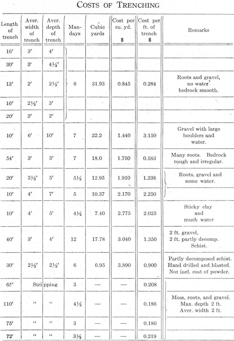
Trenches are spaced from 50 to 200 feet apart depending on the depth of cover soil. The depth should not exceed ten feet: deeper trenching is slow and costly, and the cost varies widely with other conditions. The cost of trenching may be high if there are many roots in the ground, or if water must be handled, or where the bed-rock is very rough and irregular. If the bed-rock exposed in a trench shows any signs of oxidation or secondary enrichment, (seldom more than two feet below rock surface in the Quebec gold-area) it must be removed by drilling and blasting before any samples are taken. Data on the approximate costs of trenching, under different conditions, in the Quebec gold area, are tabulated below.
Sampling a trench: — After the bottom of a trench has been properly dressed, so that nothing but fresh and unaltered rock is exposed, the trench is divided longitudinally into 5-foot sections. From each section a sample is taken by chipping out a channel 5 feet long, 3 inches wide, and half an inch deep. For cutting the samples moils are used, also a 4-lb. hammer with a short handle and a stiff broom. The bottom of the trench is first swept clean, then the sample is collected by setting a box on its side and using the moil in such manner and position that the chips will fly into the box. The cuttings from each 5-foot section are then transferred to a sample bag and labeled. One man should be able to sample from 40 to 80 feet of trench a day, depending on the hardness of the rock.
The results obtained from assaying the samples may be represented by a graph or entered directly on a plan of the trench.
Underground Exploration by Diamond-Drilling
After considerable surface prospecting and exploration has been carried out, and the existence of an orebody has been established, work should be done to prove the extent of this orebody below the surface. This can best be accomplished by means of diamond-drilling.
The dip of an orebody is not definitely established until it has been intersected by two or three bore-holes in the same vertical plane and at various depths. When the dip is known, holes can be placed to cut the orebody at desired points, with the minimum amount of drilling. But this is not always practicable, since a bore-hole tends to deviate from its course especially when the angle between the hole and the dip of the strata is small. It may then become necessary to place the hole at right angles, or nearly so, with the dip of the strata.
The core from a diamond-drill hole is carefully examined and described and a record is made including the dips and bearings of each hole. This record is used in plotting the hole and the geological sections as shown by the core. Any mineralized or other promising part of the core is cut into 5-foot sections, sampled and assayed. If it is desired to save
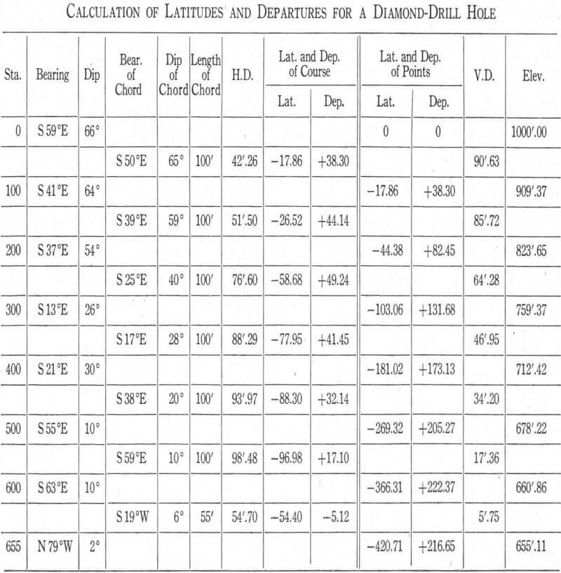
part of the core for later reference, it is split by means of a core-splitter and half is used for assaying while the other half is labeled and stored.
It is also necessary to save all the sludge from a diamond-drill hole and to assay it in conjunction with the core. If the core is badly broken and its recovery is poor, special attention should be given to the sludge and samples of it taken from every 5 feet drilled. If the core recovery is good a sludge sample from every 10 feet drilled should be sufficient.
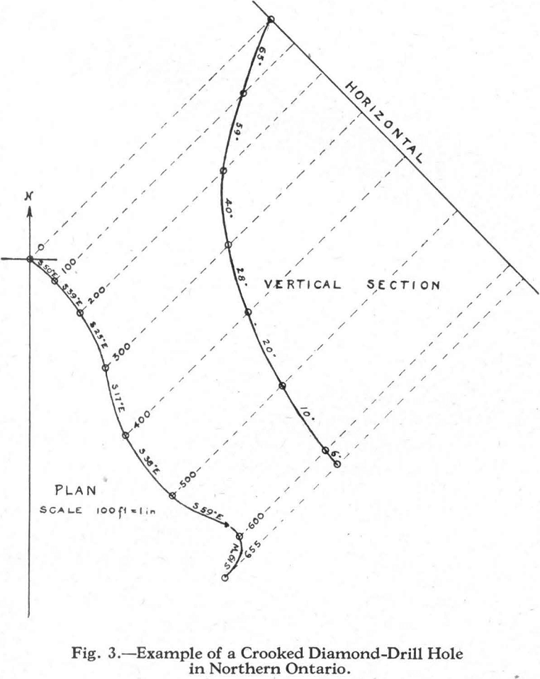
The necessity of accurately measuring the deviation of a diamond-drill hole is well illustrated by the plan and section of a crooked drill-hole shown in Figure 3. The instrument most commonly used for surveying bore-holes is the Maas bore-hole compass. The dip is measured by the etching of a glass tube by hydrofluoric acid and the bearing of the hole is obtained by a small magnetic needle suspended in liquid gelatine. The instrument is allowed to remain in the hole until the gelatine hardens sufficiently to hold the needle at the magnetic bearing. Another method of measuring the dip and bearing of a bore-hole is by Oehman’s photographic apparatus, which contains a small plumb-bob and a magnetic needle; the relative position of each in the bottom of a hole is determined by a photographic exposure.
The disadvantage of both of the above methods is that they cannot be used in magnetic ground. This difficulty has been overcome by the Kiruna method, recently developed in Sweden. A solution of copper sulphate in a container is lowered into the hole and copper is plated out on a cathode. The dip of the hole is obtained from the angle at which the metallic copper is deposited and its bearing is calculated mathematically from the shape of the elliptical upper-edge of the copper which is plated on the cathode.
Conclusion
The opportunities in and future possibilities of this new mining area in Quebec are almost unlimited, and the vast region of pre-Cambrian rocks in northeastern Canada undoubtedly contains many similar areas as yet unknown. The prospector who has not as yet acquired any ground in Quebec should not be discouraged by the fact that the greater part of the so-called Rouyn area is staked, as claims are abandoned and restaked continuously.
The development of this mining area means the construction of roads and railways, and eventually the growth of towns and cities which will carry the present frontier of civilization northward. Therefore, the prospector in searching for new mineral areas renders valuable assistance in the development of this great Dominion.
