Table of Contents
This report is a sequel to earlier Bureau of Mines investigations which indicated the need for a seepage environmental research investigation relative to the slime zone of a typical tailings pond.
In the previous studies, slope stability and location of phreati.c surface were of prime concern; consequently, only the outer portion of the pond embankment was studied in detail. To the authors’ knowledge, there has been no previous research on the characteristics of seepage through the slime zone, which is the prime objective of this investigation.
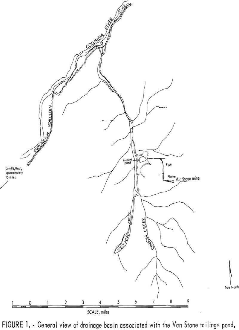
The Van Stone mine tailings pond in northern Washington (fig. 1), constructed by American Smelting and Refining Co. and currently owned by Callahan Mining Co., was used as a field laboratory for most of these studies. Climatically, the area has a January average temperature of 23.8° F, a July average of 67.3° F, and an average yearly differentiation of 135° F, with a high of
106° F and a low of -20° F. The annual precipitation averages 16.35 inches, with the greatest in November, 2.14; December, 2.03; and January, 2.01; and the least in July, 0.74; and August, 0.71. This pond is typical of peripheral discharge-type tailings disposal systems. Data obtained here should be applicable to other mill waste disposal systems.
Some dissolved and suspended solids are present in the free water of all tailings ponds. The principal contribution of this research is to identify the influence of the slime zone in preventing these solids reaching the environment outside the tailings pond.
To accompolish this, answers to the following questions had to be obtained:
- How much water is discharged from the tailings disposal system via seepage?
- Is this seepage an environmental problem?
By a series of field investigations, samplings, data collection, and laboratory and model analyses over a period of 2 years, adequate information was obtained to answer these questions.
General Geology
The ore bodies in the Van Stone mine are a few hundred feet from the contact between the Cambrian Metaline Limestone and granite of Mesozoic age. The predominate ore minerals present are sphalerite, galena, pyrite, and pyrrhotite, with zinc and lead being the principal metals sought. X-ray diffraction analysis of tailings from the main pond indicates that they consist predominantly of dolomite, quartz,and unidentified feldspar, tremolite, and possibly some calcite. The ore minerals are not in sufficient abundance in the tailings to reveal themselves under X-ray diffraction without preconcentration. Additional details of the geology in the Metaline district are presented by Park and Cannon.
The tailings pond is situated over the Mesozoic granite, but the granite is covered by a layer of topsoil of variable thickness. The topsoil layer consists of varying thickness of dark brown organic silt, about 12 inches of
tan, silty, sandy gravel, then clean, gray, sandy gravel and decomposed granite. Glacial activity has occurred in the area.
Van Stone Field Investigation
Sampling, Instrumentation, and Field Observations
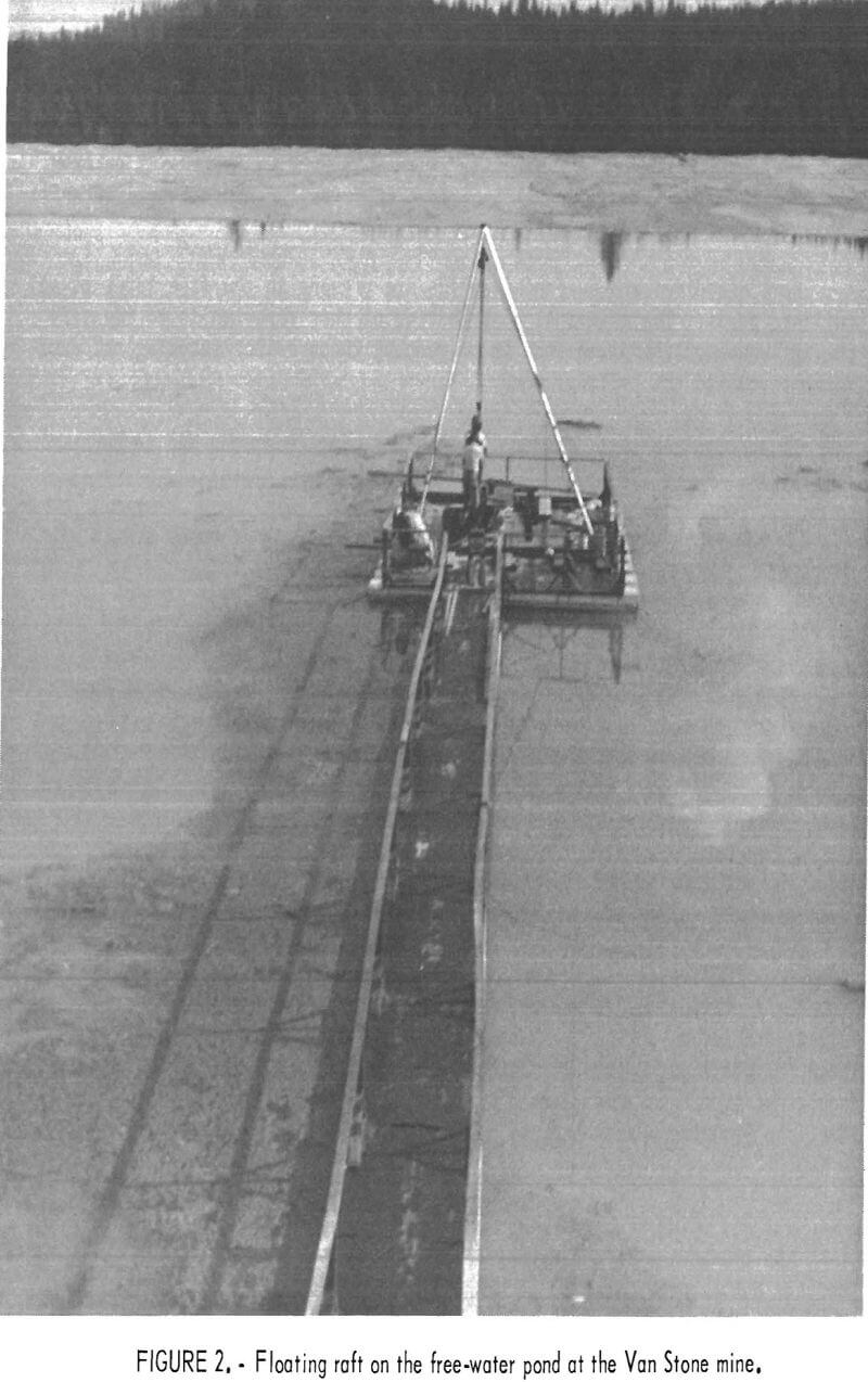
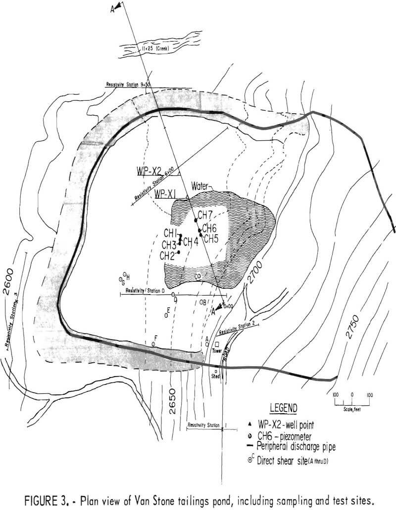
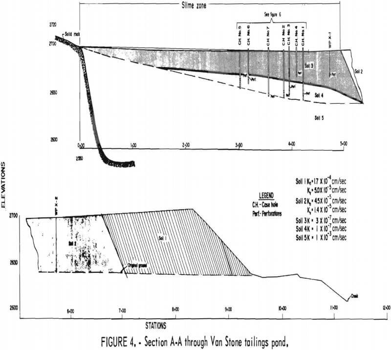
Soil sampling of the slime zone was accomplished by use of a floating raft (fig. 2) with a 20-foot tripod mounted on its deck. Slime samples were obtained at locations shown in figure 3 and at elevations shown in figure 4. Cased holes 1, 2, 3, and 4 were not on section A-A, but were projected to their respective positions, shown in figure 4, to expand the data along this section. They were projected to their proper position with respect to surface and subsurface elevations. The individual samples were extracted using a plexiglass “Shelby-type” tube fabricated at the Spokane Mining Research Center (SMRC). The plastic tube was inserted in a steel sleeve with a cutting edge. A 1/16-inch-OD plastic airline was attached to “break suction” when
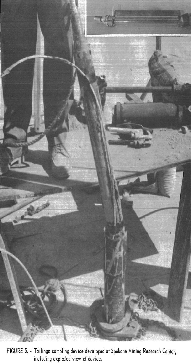
removing the slime sample and tube from the hole (fig. 5). The assembly and airline were designed to minimize sample disturbance. The plexiglass tube and steel sleeve were driven with a hydraulic jack which was trussed to the 4-inch steel casing.
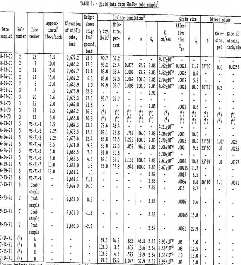
Several physical properties were determined for each of the tube samples. To complete the field sampling requirements for mathematical modeling, sub-strata samples were taken in both the horizontal and vertical directions from trenches excavated 10 feet deep adjacent to the embankment. The data from these samples are presented in tables 1 and 2. Several of the parameters which were obtained are not used in the mathematical model developed in this report. However, they are the only data of this type available and are included for use by other researchers pursuing other objectives, particularly those involving design.
Consolidation and Grain Size
Although the field data, shown in table 1, were obtained primarily to establish permeability and soil structure in the slime zone, other pertinent information was obtained. The data show very little pattern with respect to position or depth. This tends to substantiate the theory that, aside from relatively small layered deposits, the mass of slimes, is, in general, homogeneous. However, there are three rather distinct zones with respect to depth; consequently, blow count data (table 1), field observations, and slime samples were used to define three slime layers for the mathematical model. These zones are characterized by little or no consolidation of the upper 5 to 10 feet of slimes directly below the free-water surface, medium consolidation of the middle depth, and greater consolidation of the lower 5 to 20 feet of the slimes. This lower layer feathers out upstream because of lack of consolidation due to the lesser thickness of tailings. (See pond section, fig. 4.)
The different hardness and consistency are due to the degree of consolidation, which is limited near the top. At greater depths, the neutral stresses are lower. Near the bottom there is low neutral stress and greater drainage due to the proximity of the interface with the more pervious original ground. This combination would facilitate higher effective stresses and concomitantly a higher degree of consolidation. Table 1 shows the common case of increasing blow count in driving casing as the depth increases. Some of this increase could be attributed to skin friction, but the facts that harder samples were observed and that on at least two occasions the casing began to pull when used as “hold downs” for driving tubes would indicate that the skin friction was not a significant factor.
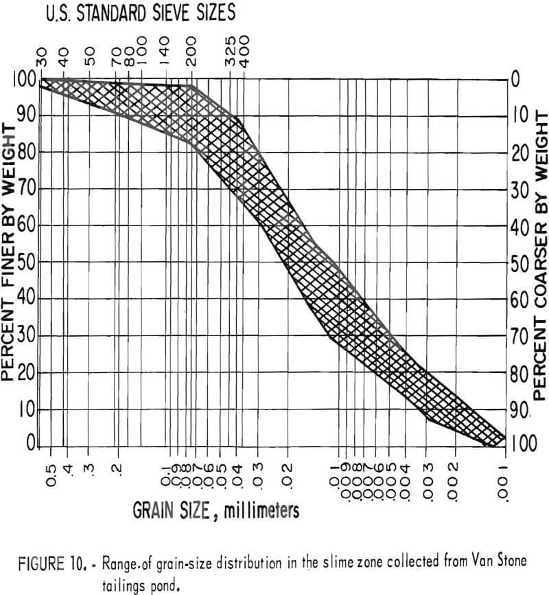
The grain-size analyses indicate that the material is well graded and the effective size is quite small. The range of values obtained from permeability tests substantiate this fact. In summary, the tests show that the tailings are a fine-grained, sandy silt with slight cohesion.
Table 1 illustrates the near-uniform permeability of the major portion of the mass, which verifies the homogeneity of the slime zone.
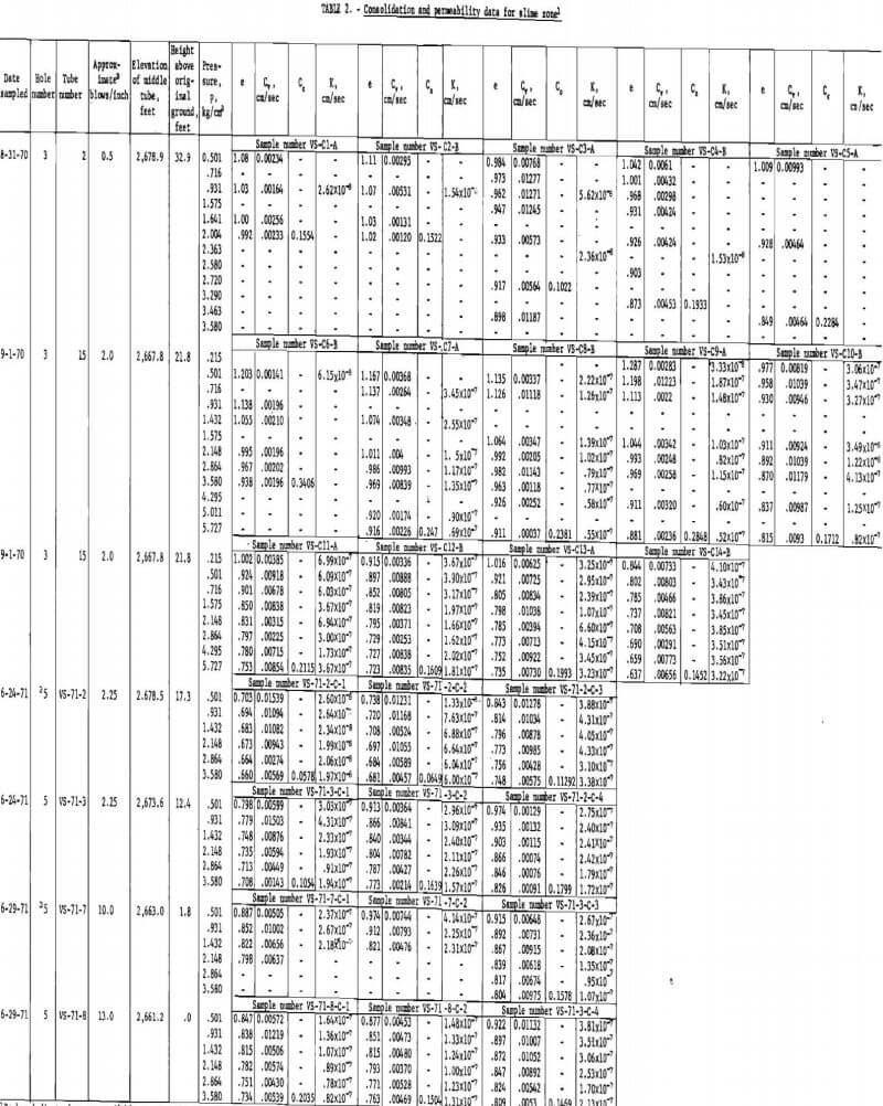
The consolidation and permeability data in table 2 also demonstrate the uniform consistency of the slime zone. It is also apparent that consolidation loads much higher than those which exist in the field do not increase the density significantly. As would be expected, the permeability factor decreases with increased pressure, but the change is relatively slight.
Water Movement
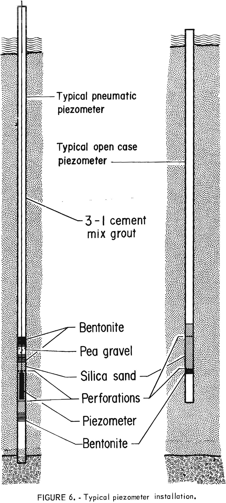
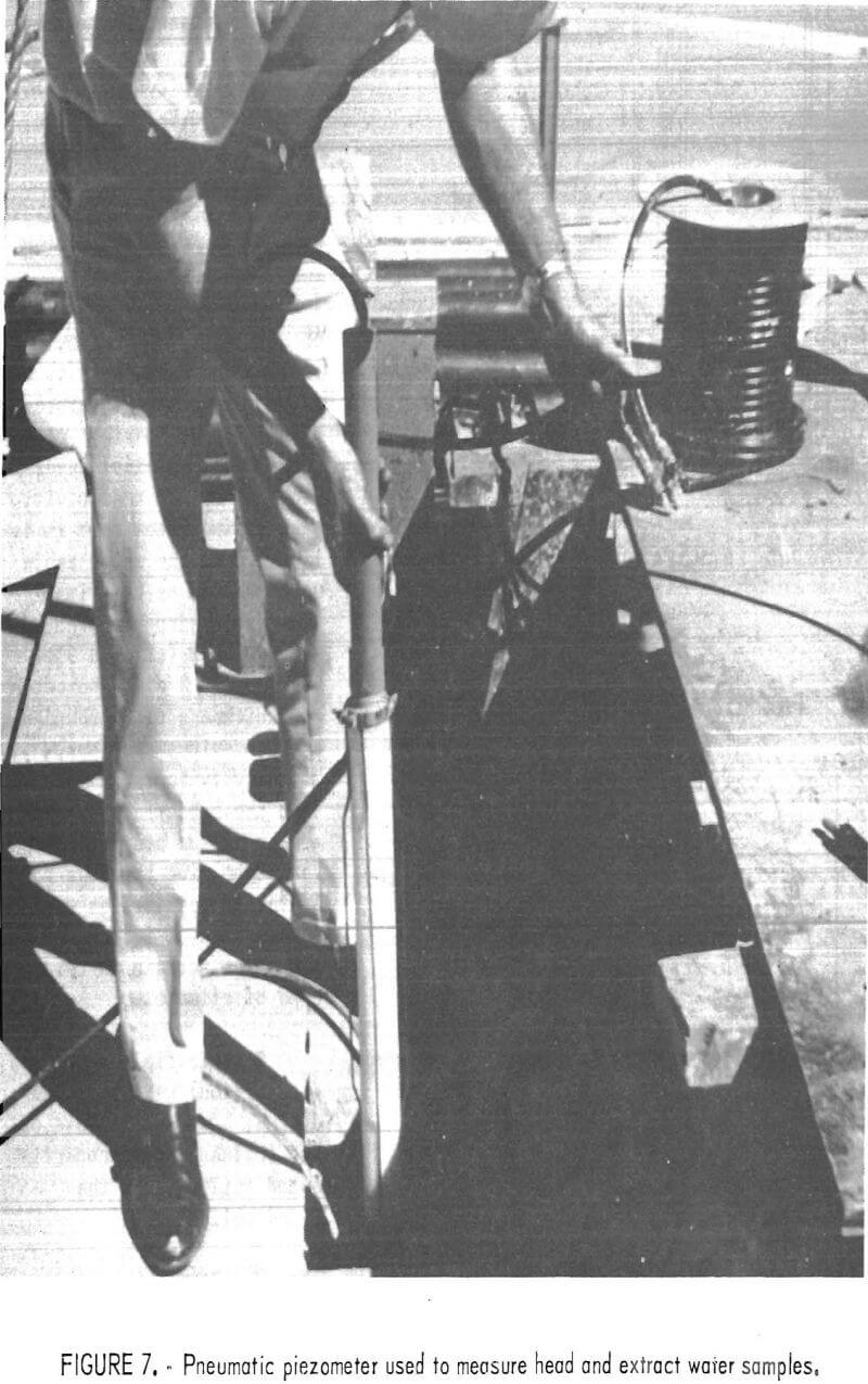
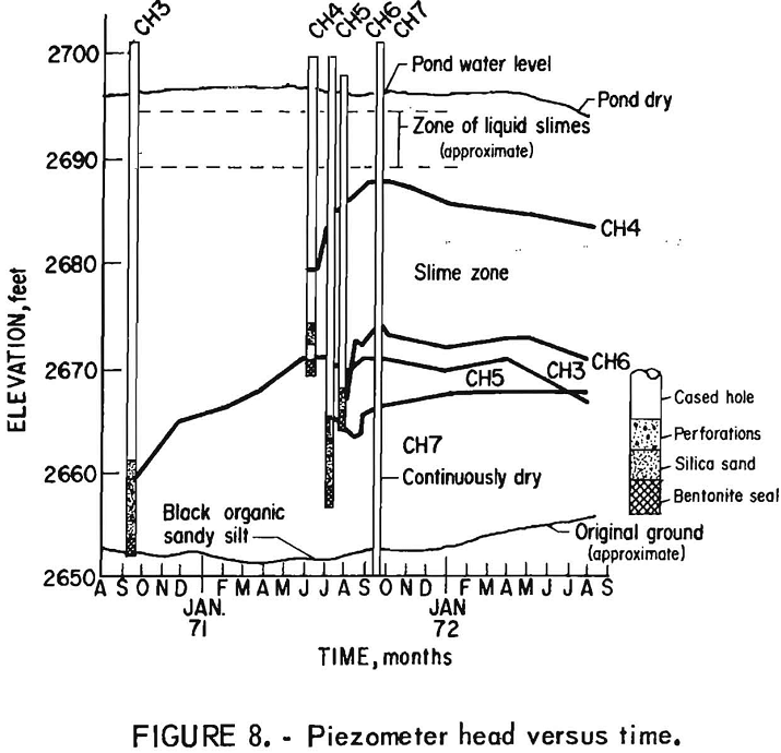
All of the drill holes were cased with 4-inch-diameter steel pipe to hold the hole open for extracting samples at depth. The completed cased holes were perforated and converted into piezometer installations as shown in figure 6. Two of the cased holes were fitted with pneumatic piezometers for water-quality testing (fig. 7). Figure 8 shows the piezometer readings in the cased holes from the time of perforation through August 1972, at which time the study had terminated. The data indicate that there is approximately a unity head loss as the water moves downward through the slime zone. In all cases, except CH3, the head decreases with depth. (CH3 may have an anomalous reading due to its position near the area where the tailings were dumped during freezing weather.) Thus, it appears that in order to minimize seepage through the slime zone, it is important to either minimize the depth of slimes with a fixed pond water depth, minimize the water depth with a fixed slime depth, or minimize the permeability of the slimes zone. Because of the low heads in CH1 and CH2, the pneumatic piezometers, which were designed for high heads, failed to work and no data was obtained from them. CH7 was driven into the original ground, which is a dark brown, organic sandy silt. This hole has never shown any water, which probably indicates that there is an unsaturated lense at this level.
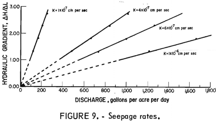
Darcy’s law may be utilized to estimate the rate of flow through a given soil. Accordingly, the rate of seepage is proportional to the gradient for a constant permeability and area. If several values of K, the permeability factor, are used, a family of curves can be obtained for various values of gradient (fig. 9). These curves illustrate the importance of controlling the hydraulic gradient to minimize seepage through the slimes. Controlling the gradient, of course, means controlling the pond water level. The curves in figure 9 demonstrate the importance of water level control because of its effect on the gradient across a fixed flow path length.
Field Resistivity Tests
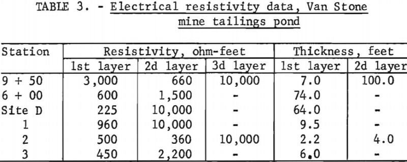
Resistivity tests were conducted to determine the ground water table configuration and to extend the knowledge of depth to bed-rock obtained from drilling and outcrop mapping. Figure 3 illustrates the location of the resistivity lines. Table 3 shows the results of these tests. The interpretation of the possible meanings of the physical layers detected by the resistivity methods indicates that it is likely that the water table was detected as the first layer and bedrock or the second layer (station 9 + 50). Table 3 also indicates the thickness of overburden at the various-stations. Resistivity tests indicate that the subsurface topography of the bedrock in the Van Stone mine tailings pond is very irregular, as would be expected of igneous intrusive terrain in this type of climate.
Seismic field tests (refraction) were also conducted; however, because of the influence of unconsolidated tailings and the embankment “free face,” the results were not considered reliable.
Laboratory Data
Permeability tests on the undisturbed tube samples were conducted as described in reference 7. One weakness of the earlier testing method was eliminated by utilizing plexiglass tubes instead of steel tubing. This allowed visual inspection of flow during testing, thereby eliminating the possibility of undetected percolation of water along the tube wall. ASTM standard testing was used to develop the physical properties of the slimes the laboratory, as shown in tables 1 and 2. Figure 10 shows the range of grain-size distribution of slime samples collected from the Van Stone pond.
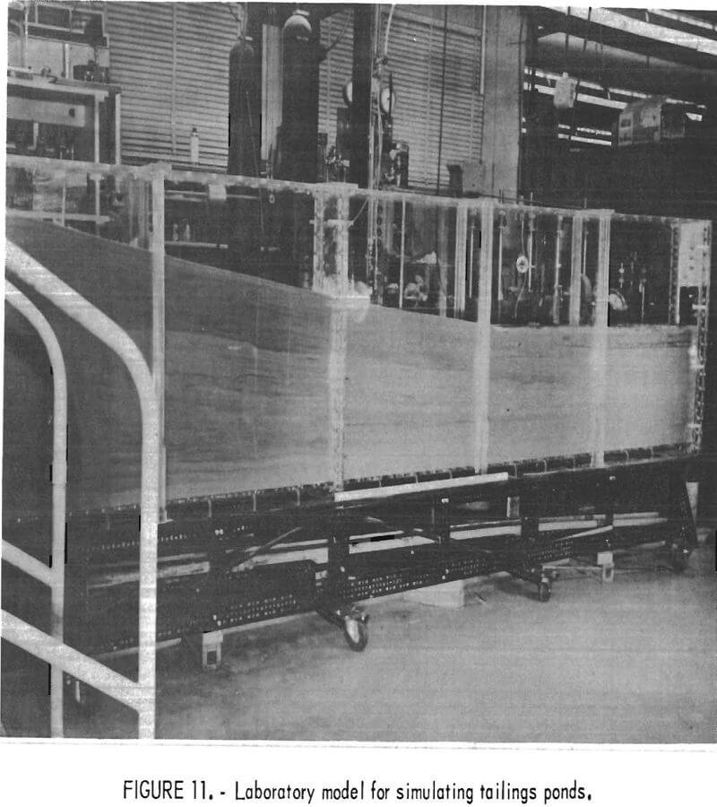
To supplement field testing, a plexiglass physical model 16 feet long, 3 feet high, and 6 inches wide was constructed (fig. 11). Tailings were introduced into the tank and tested to confirm field observations and develop additional permeability data for the mathematical model discussed subsequently. Tailings disposal operational procedures were tested in the laboratory model to confirm their practicality.
Environmental Field and Laboratory Investigation
The Van Stone tailings pond is located in a watershed which is one of the three tributaries of Onion Creek, a tributary of the Columbia River (fig. 12). A second major tributary of Onion Creek runs along the north boundary of the tailings pile.
The third tributary of Onion Creek, which flows from the south, is impounded in several places by beaver dams. Because of the lack of mining activity and human habitation, this tributary was utilized as a control for water quality data.
Stream Sediment Analysis
The Van Stone embankment and pond were designed so that the decant water enters either the north or south tributary of Onion Creek. When the effluent flows to the south, it passes through two small holding dams (fig. 12); it was observed that the water cleared appreciably and that deposition of slimes was evident on the bottom of these ponds.
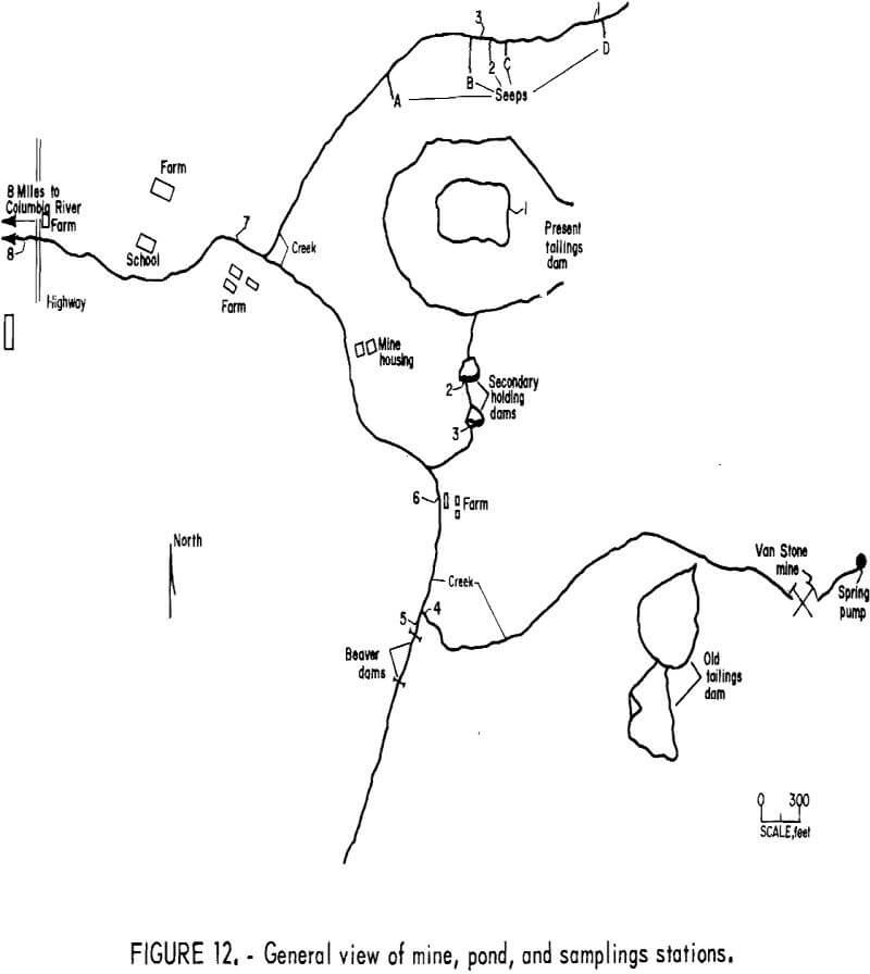
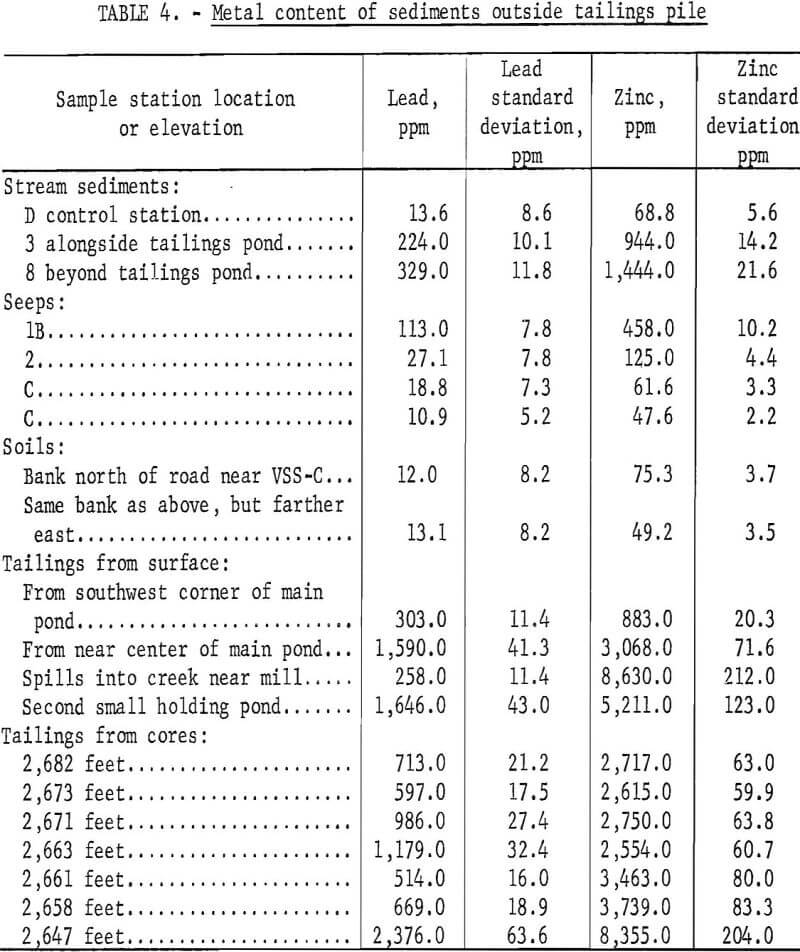
To examine the extent to which sediment from the tailings water has entered the drainage down gradient, sediments from Onion Creek and its eastern tributary which flows alongside the tailings pond were analyzed for lead (Pb) and zinc (Zn). Sediments near a few seeps along the stream were similarly analyzed, as were the tailings themselves. Specimens of nearby soil were also analyzed to determine if the lead and zinc content was sufficiently great to make an appreciable contribution to the trace metal content of the sediments near the seeps.
In all cases , the sediments were dried and sieved so that only grains smaller than 250 mesh were analyzed. This mesh size was selected because it permitted the tailings material but not the pebbles and coarser sand to pass. Eight-gram samples to which 1,000 ppm of arsenic (As) had been added as internal standard were analyzed by measuring the intensities of characteristic X-radiation emitted by the samples when exposed to white radiation. These intensities were compared with those of standard specimens containing lead, zinc, and arsenic. Corrections for matrix effects were made in the manner of Hower.
Results of the analyses are tabulated in table 4.
Results and Conclusions of Sediment Analysis
Sediments from VSS-D, the control station immediately upstream from the tailings pond, were found to contain 14 ppm Pb and 69 ppm Zn. Compared with the average abundances in the earth’s crust and its rocks, these values, expressed in parts per million, are similar to normal concentrations:

In contrast, the tailings from the deeper portion of the pile contain concentrations of lead and zinc two orders of magnitude greater than in the natural soils. In one-half of the sediments collected adjacent to the slopes and in both the stream sediment samples taken downstream from the tailings pond, lead and zinc were well in excess of the amounts in the soil or in average crustal rocks. Therefore, it is probable that these sediments result from some admixture of tailings and normal stream sediments; significant contamination of the seep sediments and the stream sediments could not have occurred from the surrounding soils, and the anomalous sediments are therefore attributed to the tailings pond material. Erosion of the tailings pile or accidental discharge of tailings into the stream and seeps at some time in the past are probably the mechanisms which produced the anomalous conditions observed in the stream and seep sediments.
The concentration of lead in the tailings beneath the pond was not found to vary in any regular way with depth, but zinc was found generally to increase with depth in the tailings pile. Two hypotheses for the variation of zinc with depth are the zinc is somehow mobilized so as to move through the layers in the pond, and the efficiency of the milling operation increased over the years. The mechanism described by Mink, Williams, and Wallace may be applicable if hypothesis 1 is the case.
For comparative purposes with the X-ray spectographic analysis, two of the Shelby-tube slime samples were digested and analyzed by atomic absorption spectrophotometry. The analyses show that the critical metal ions (Zn, Pb, Cd, Cu) are concentrated in the silt- and clay-size portion of the sediments, which is in agreement with the observations of Galbraith, Williams, and Siems. A complete description of the concentration of elements in each zone is shown in appendix A. On the basis of these data, it appears that it is particularly important not to permit erosion or escape of the finer fraction of tailings during or after disposal because this fraction is likely to contain the majority of the heavy metals that might be potentially harmful to aquatic life.
The following concentrations of zinc and lead were observed in water samples extracted from the piezometers at the base of the slime zone:
Zinc =0.03 mg/l
Lead =0.1 mg/l
Water Quality of Receiving Stream
Extensive physical, chemical, and biological data were collected at the site to determine the environmental impact of the tailings pond. These analyses were conducted by Barry, and a more detailed publication is forthcoming. The data show that it is not advisable to determine the influence of the tailings pond on the environment with chemical and physical data alone. A concomitant evaluation of the local biota is advisable also.
Water and sediment samples indicate minor changes in the water quality in the drainage basin. This is a result of two factors: (1) The tailings pond effluent is relatively low in suspended and dissolved matter, and (2) there is considerable dilution of water discharging from the pond. However, on the basis of organic detritus data and previously discussed data on stream sediments, some damage to first and second trophic levels has occurred. This is due primarily to the escape of suspended solids via the decant system or to erosion of unvegetated embankment slopes. Therefore, these data also demonstrated the need for careful control of pond water level for suspended solids removal and the need for design and planning of tailings piles for abandonment, particularly with respect to revegetation of embankments. Additional details on aquatic effects to be anticipated are presented by Hutchinson and McKee and Wolf.
Discharge systems other than the peripheral type allow free water and sometimes slimes to lie against the embankment, thus permitting very little consolidation and poor arrangement of slimes. Consequently, in such instances, permeability in the outer portions of the embankment remains high and the water is allowed to flow through the dike system; ultimately, the dam may even fail if great care is not taken during the construction period.
Finite-Element Analysis
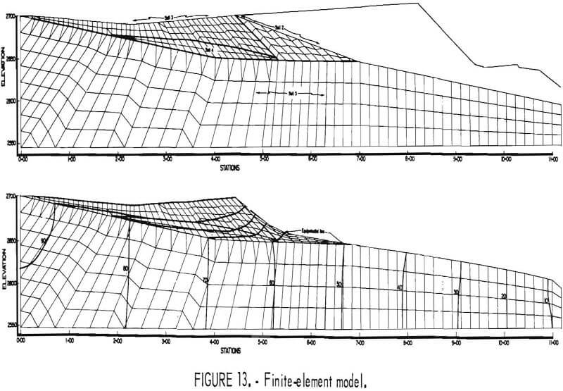
The finite-element method of analysis was selected to analyze subsurface flow out of the tailings pond since traditional flow net methods are cumbersome to use when handling several soil zones and complex geometry. The finite-element computer program developed by Taylor was used in this study, as in the earlier investigations.
The section to be modeled, shown as section A-A on figure 3, was selected so that ground water seeps and impervious bedrock could be incorporated into the mathematical model (fig. 13) as boundary conditions. The various soil zones as determined from field sampling and analysis and respective coefficients of permeability were also used as input to the program.
According to the field data, two basic ground water flow systems may occur in the vicinity of the pond: (1) A saturated system overlying a more permeable partially saturated one that is, tailings, embankment, and sub-strata is hydraulically disconnected during low ground water table conditions (“perched” conditions); and (2) a hydraulically connected system exists during high ground water table conditions where no unsaturated zone exists directly beneath the tailings. It is possible also to interpret the data to mean that a permeable, partially unsaturated lense exists under only part of the tailings pile.
The second case was readily analyzed, but because our computer program is limited to steady-state saturated flow conditions, the partially saturated zone case could not be included in the model.
It was concluded that the most reasonable approach would be to neglect any unsaturated ground water effects and model the tailings on the highly permeable substrata with all recharge water in the system derived from the pond. Approximate agreements of field piezometer readings and nodal pressures lend credence to this approach. Appendix B contains a listing of nodal pressures, nodal potentials, and element velocities. The potential distribution is superimposed over the final finite-element mesh in figure 13. The element velocity distribution normal to the tailings natural ground contact is shown in figure 14. Figure 14 was used to calculate the leakage out of
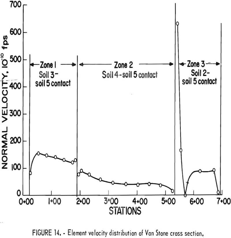
the bottom of the pond. The element leakage rate, that is, flow perpendicular to the lower boundary, adds up to 410 gallons per day per acre for the Van Stone pond.
Environmental Design Criteria
Several environmental design criteria can be recommended based on the study. Water control is by far the most significant design and operational parameter. The water can be controlled by (1) utilizing the slime fraction of the tails (low k) to form the boundaries of the free water, (2) controlling the elevation of the free surface water, relative to the pond slime zone, and (3) implementation of all recycling possible.
A closed mill water circuit should be the objective of all tailings disposal systems. Retention ponds located in series can provide effective treatment for most constituents (see Williams, Wallace, and Mink, (15); however, if pH values are not sufficiently high, a few elements in tailings are not receptive to the technique. Most notable of these is manganese because of the low limit placed on it in the Environmental Protection Agency guidelines for the mining and milling industry. These ions can be handled most efficiently by total recycling of the water. A problem arising from such a technique is that recycle water may be detrimental to the efficient operation of some metallurgical circuits. However, based on current environmental pressures, it appears that it may be far more costly to treat pond effluents than to adapt metallurgical circuits to use water emitted from a mill tailings pond.
The statement that surface water is more troublesome than seepage water is true only if a peripheral discharge system is used. If the disposal system uses other methods, for instance, a homogeneous dam, and if expensive low-permeability liners are not installed, the seepage water may become as much of a problem as surface decant water owing to the high rate of seepage resulting from a high phreatic surface within the embankment.
The peripheral discharge system allows the slimes to become consolidated, and the lense of slimes forms a boundary approximately parallel to the outside embankment. Thus, the lower lifts are always larger lenses than the upper lifts; consequently, they preclude high rates of water flow out of the bottom of the pond.
The computer analysis revealed that the tailings pond contribution to the total ground water system (recharge) is not great. Summation of the element flows normal to the natural ground contact results in a discharge of approximately 410 gallons per day per acre of pond water surface.
Using this discharge rate and the analysis of water samples taken from piezometers at the base of the slimes, metals would reach the environment outside of the pond at the following rates:
Zinc =0.04 lb/yr/acre
Lead = 0.12 lb/yr/acre
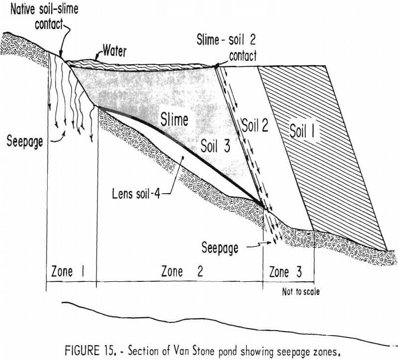
Analysis of figure 14 in conjunction with figure 15 reveals that about 37 percent of the total seepage occurs through zone 1. This seepage could be substantially reduced by proper preparation of the natural ground contact prior to pond construction.
Zone 3 is the most critical section for seepage. With the pond surface at the slime, soil 2 contact seepage through zone 3 amounts to 36 percent of total discharge. Raising the water surface above soil 2 results in greater seepage through this more permeable soil. Lowering the surface below the slime zone-soil 2 contact reduces total seepage through zone 3.
Complete elimination of seepage through zones 1 and 3 would result in a total discharge of approximately 110 gallons per day per acre of surface.
Conclusions
- Evaluations of the need for (and type of) technological solutions to today’s environmental problems require a multidisciplinary approach. Expertise in four major fields was required for the study discussed herein; mining-metallurgical engineering, limnology, soil mechanics, and hydrogeology.
- The fabricated plexiglass tube is an inexpensive, practical, and effective slime sampling and testing device.
- The development of a low-permeability soil zone at the bottom of the slime zone (a result of load and a drainage face) indicates that tailings disposal on any soil base can eventually become environmentally safe, if the slime zone is manipulated properly.
- According to mathematical model output, the volume of water discharged into the ground water flow system from the Van Stone tailings pile is 410 gallons per day per acre of surface water. This quantity of flow would not be significant in most drainage basins and, therefore, would not be detrimental to the environment. However, it should be possible to approach a leakage rate as low as 110 gallons per day per acre by use of a peripheral discharge system which is carefully designed and operated and which receives only mill wastes of near standard grind.
- The results of this research strengthen the case for building peripheral discharge dams when both coarse and fine materials are available, because they are not only stable structurally, but also form a slime lense zone which, when properly manipulated, protects the local ground water flow system. If other types of embankments are used, the slime zone should still be manipulated, protects the local ground water flow system. If other types of embankments are used, the slime zone should still be manipulated to minimize subsurface leakage.
- The pond water should be recycled. Without treatment, the escape via the decant system of a few parts per million of detrimental dissolved ions is extremely difficult to eliminate.
For the Van Stone tailings disposal system, suspended solids are the most detrimental, but can be minimized by proper retention time and a carefully designed and managed decant system. For a small pond, the dissolved solids in the decant effluent constitute the most expensive problem to handle. - Control of subsurface leakage can also be minimized by operational control of the free-water level in the pond; such control prevents free water from extending out over the slime zone-soil 2 contact, thereby minimizing leakage along this zone of higher permeability. Preparation of the surface of the natural soil prior to disposal should be considered also.
- Deposition of slimes against the face of a homogeneous dam without peripheral discharge will not provide an efficient seal unless expensive design techniques are utilized, because the upper 15 feet will remain unconsolidated (low k); thus high rates of seepage will occur through the downstream face of the embankment. This, of course, is structurally and environmentally undesirable.
- Use of the biota as an index of pollution provides the best common denominator for assessing the effect of waste water on the environment. Physical and chemical data alone are difficult to interpret.
- More research is needed to determine the influence of the slurry density upon the angle of deposital tailings and the associated seepage loss prior to reaching the free water pond. This additional research in combination with the recommendations presented herein should minimize many of the waste disposal problems discussed by Williams.
