Table of Contents
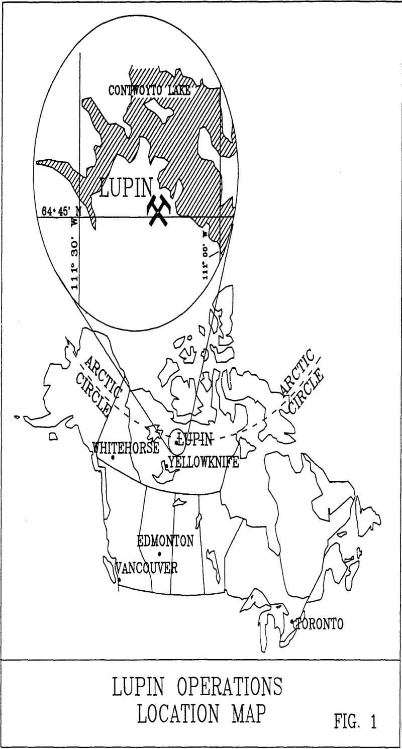
Lupin is located on the shores of Contwoyto Lake at lat. 65° 48’N, Long. 111° 15’W and lies about 80 kilometres south of the Arctic Circle. Since start up in 1982 the mine has produced over 2.15 million ounces of gold from 6.66 million tonnes of ore grading 10.63 gm/tonne. Total remaining reserves at 1993 year end were 5.1 million tonnes at a grade of 9.11 gm/tonne (1.65 million ounces). This is sufficient for 7 – 8 years at the present annual production rate of about 200,000 ounces. The Centre and West Zones of the deposit are open to depth.
Controls of Gold and Sulfide Distribution at Lupin NWT
Different processes have been suggested for the formation of the Lupin deposit including synsedimentary deposition of gold and sulfides, epithermal emplacement of gold, metasomatic emplacement of gold and sulfides, redistribution of gold and sulfides during metamorphism and combinations of the above. There is no unequivocal argument in the literature for any of the possibilities noted, although different authors have their own biases. The geological staff at Lupin deals with the deposit on a daily basis over long periods of time and bases their ideas and opinions to a large degree on field observations and intimate understanding of the geology of the deposit. On the basis of observations and studies described in this paper it is the opinion of the authors that the Lupin gold deposit was formed subsequent to peak regional metamorphism probably by gold-bearing metasomatic fluids circulating in the cooling sedimentary pile and channelled along structures resulting from earlier deformation.
Regional Setting
Geology
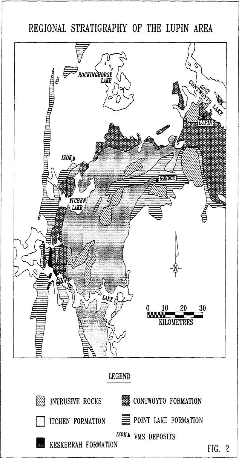
In the Contwoyto Lake area this Supergroup is subdivided into four formations according to Bostock (1980) as follows: the Contwoyto Formation, composed of interbedded greywacke and mudstone, containing lenses and horizons of iron formation, and a locally significant volcanic component; the Point Lake Formation, composed of mafic to felsic volcanic rocks; the Keskarrah Formation, comprised of conglomerate and lithic sandstone; and the Itchen Formation, composed of greywacke and mudstone beds lacking iron formation.
Iron formation within the Contwoyto Formation does not appear to be preferentially deposited within either greywacke- or mudstone-dominated sequences. The Point Lake Formation is highly variable in content and comprises mafic flows and tuffs, as well as felsic volcanic rocks and minor sedimentary units . The Keskarrah Formation is confined to Point Lake where it occurs as clast- and matrix-supported conglomerate and sandstone.
Deformation
Structures produced during D1 are rarely visible in outcrop, and are inferred from changes in facing direction or from variations in bedding and cleavage relationships. These folds are tight to isoclinal with steep axial planes and subvertical plunges. Fold wavelengths vary from a few centimetres to 100 metres. The S1 axial planar cleavage is defined by an alignment of biotite and muscovite, and locally remains as small scale alignments lying between S2 surfaces.
Second phase folds (F2) are tight to isoclinal with typically steep plunges and near vertical axial planes. The folds generally have wavelengths of only a few metres. S1 is commonly subparallel to the axial planar foliation S2, which dominates the area. During D3, F3 folding created crenulations to folds with wavelengths that are commonly less than one metre, but which may be up to 50 metres. The northern portion of the East Zone at Lupin is probably an example of the broader F3 folds. These folds also plunge steeply and have near vertical axial planes.
Plutonism
C1 to C3 plutonic events are compositionally gabbroic to granodioritic, and are coeval with volcanism. C4 and C5 plutonic rocks emplaced during D2 show a wider compositional variation, from gabbroic to granitic. C6 plutons are granitic to syenogranitic and locally pegmatitic. The C6 rocks are post- D2 to early-D3. Modal compositions and textural variations are used to distinguish various phases within each plutonic event. The Contwoyto Batholith, lying to the north and west of Lupin, is thought to have been emplaced during C6.
Geology of the Deposit
Stratigraphy
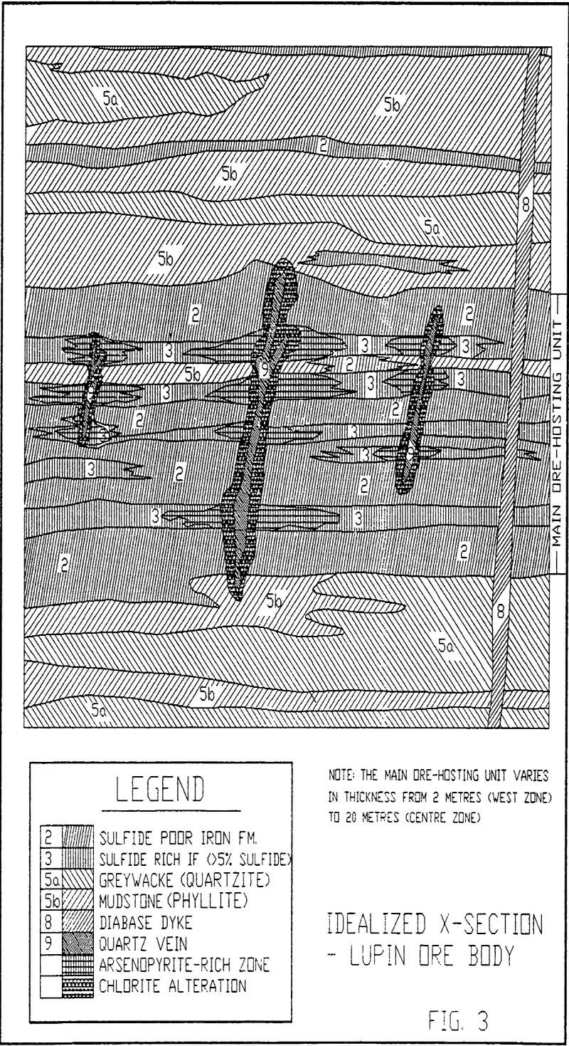
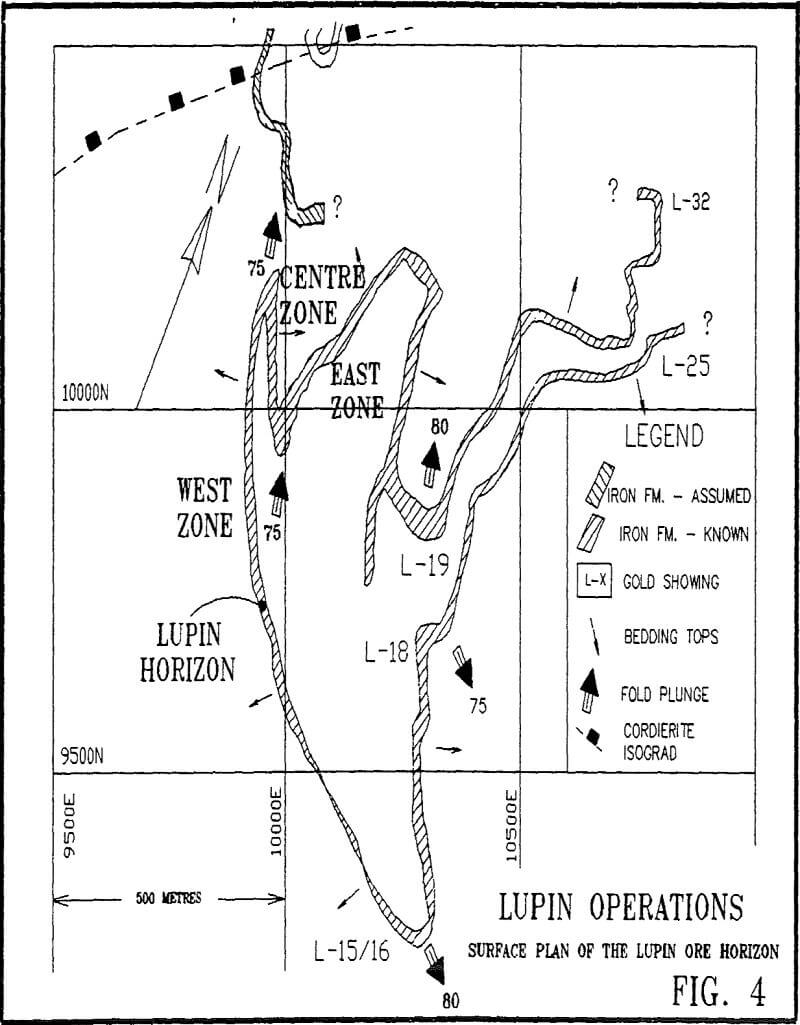
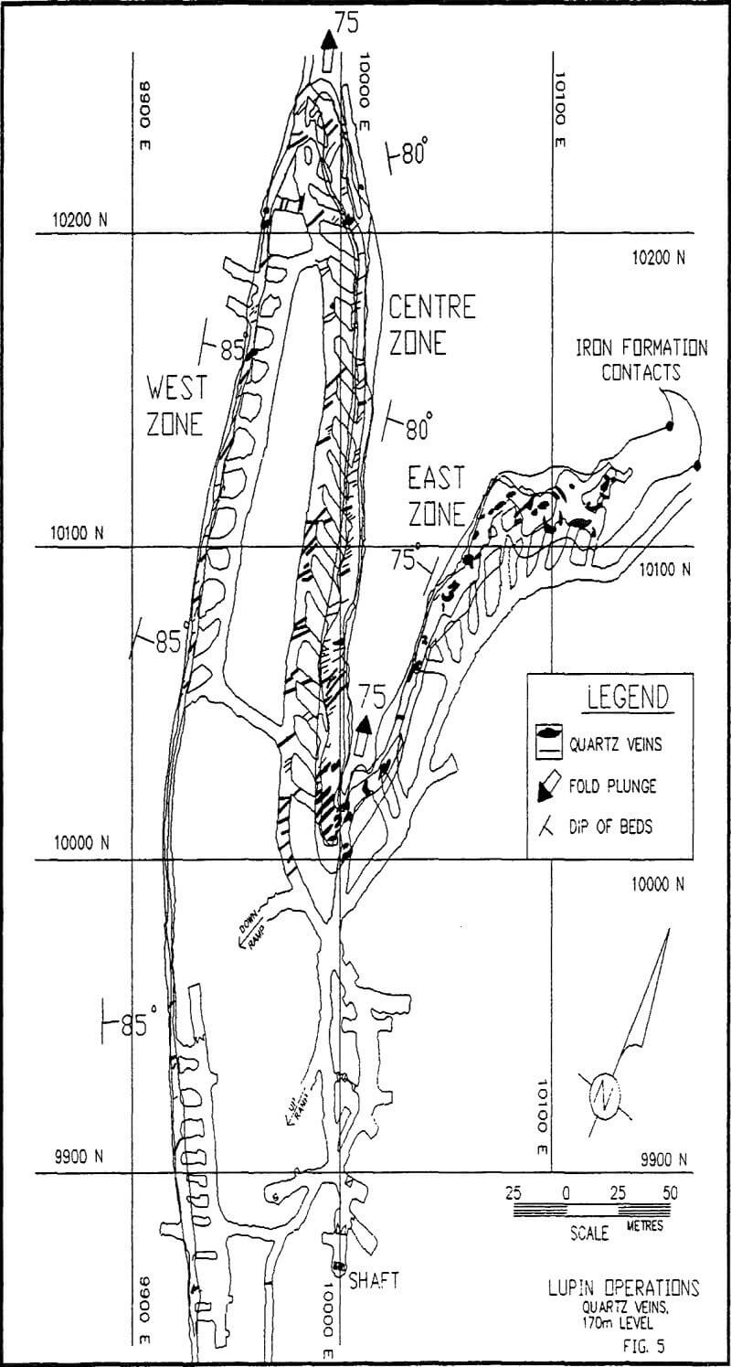
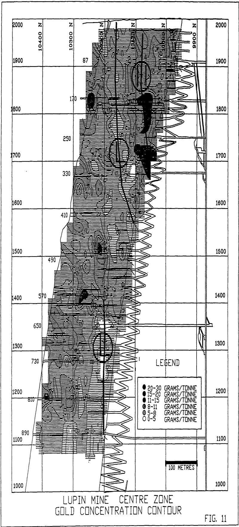
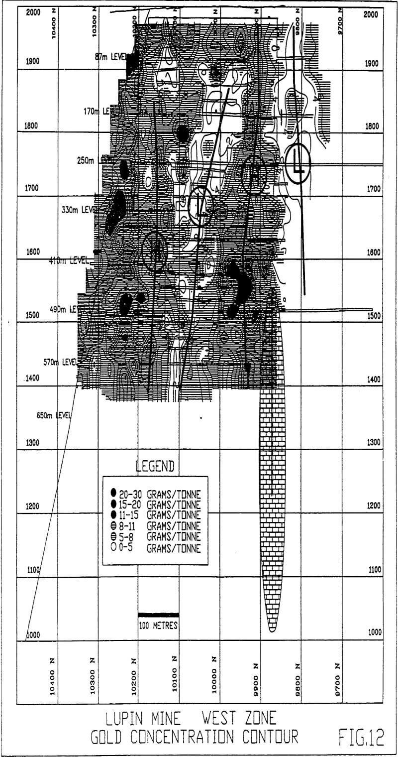
All ore zones at Lupin are confined to a continuous amphibolitic iron formation within the Contwoyto Formation which has been followed by mapping, surface and underground drilling and underground workings for a strike length in excess of 3 kilometres and a dip length of 1.2 kilometres. The main ore-hosting unit is dominated by sulfide-rich amphibolitic iron formation with minor interbeds of phyllite and quartzite.
Metamorphism
From surface to about 550 meters below surface the Lupin deposit lies within biotitic rocks of upper greenschist facies. Regional metamorphism accompanying early deformation is evident in the orientation of mica flakes parallel to axes of F1 folds. The early prograde metamorphism was followed by retrograde metamorphism as indicated by the alteration of biotite and hornblende to chlorite.
Structure
The first phase of isoclinal deformation developed before the peak of regional metamorphism and resulted in tight isoclinal folds (F1) with axes oriented northeast. Wavelengths are in the order of 100 metres and an axial planar foliation is locally preserved by oriented flakes of biotite and muscovite. These folds are isoclinal in the upper levels but broaden with depth, suggesting a domal structure. The second phase of isoclinal folding, developed during, or slightly prior to peak metamorphism, resulted in isoclinal folds (F2) with an axial planar foliation that parallels bedding and forms the main schistosity in the mine area. Axial traces strike northerly. The south fold nose of the West Zone, formed during F2, plunges steeply south and has been defined by drilling from surface to the 250 metre level.
A set of folds, initially thought to be F3 but now believed to be parasitic second phase folds, are locally strongly developed within the amphibolitic iron formation horizon. Amplitudes are in the order of a few to several metres. Axes of the parasitic folds splay as the F2 fold noses broaden with depth. Axial-plane cleavage and faulting associated with this folding controlled quartz vein emplacement and the related sulfide and gold distribution in the iron formation.
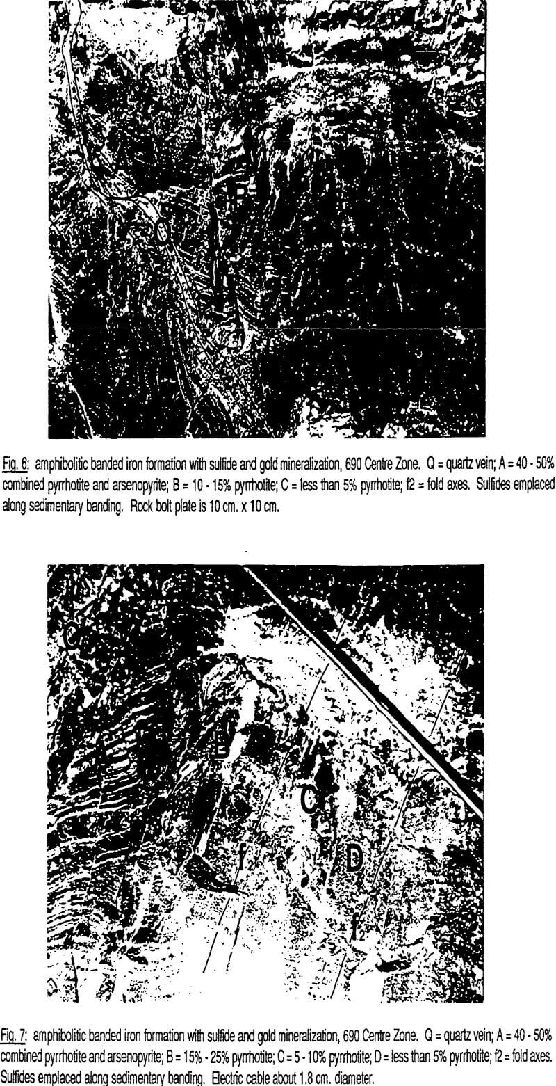
Mineralogy of the Amphibolitic Iron Formations
Garnet Amphibolite
Garnet amphibolite occurs as thin horizons or lenses, less than 1 metre thick and up to 30 metres long, within or at the margins of the iron formation. It may be schistose and may grade into rare pelitic rocks within the sulfide-rich iron formation. Garnet content is up to 90% of the rock but averages about 20%. The garnet content in garnet amphibolite at the margins of sulfide-rich and sulfide-poor iron formation decreases away from the iron formation.
Sulfide-Poor Iron Formation
Well laminated, sulfide-poor iron formation is dominant in the East Zone and the south nose of the Centre Zone below 650 level, but is present throughout the deposit. It may grade into the sulfide-rich variety and is occasionally interbedded with it. Bedding is defined by alternating grunerite, metachert and hornblende layers, and thin laminae occasionally enriched in pyrrhotite.
Sulfide-Rich Iron Formation
Gold at Lupin is finely disseminated within pyrrhotite, arsenides and silicates. Arsenopyrite occurs as large prismatic crystals up to 2cm in diameter close to quartz veins which cut the iron formation. Arsenopyrite replaces amphibole, quartz, pyrrhotite and chlorite. Metacrysts commonly have loellingite cores and much of the gold associated with the arsenides occurs at the loellingite-arsenopyrite boundaries. Petrographic studies have shown that pyrrhotite replaces, and is intergrown with hornblende, grunerite, other silicates, and arsenides in amphibolitic iron formation. Both pyrrhotite and arsenides occasionally show minor deformation, suggesting some strain in the iron formation subsequent to crystallization of sulfides. In polished thin sections, pyrrhotite often occurs within foliation planes in amphibolitic iron formation, suggesting late, structurally controlled emplacement of pyrrhotite.
Quartz Veins and Mineralization
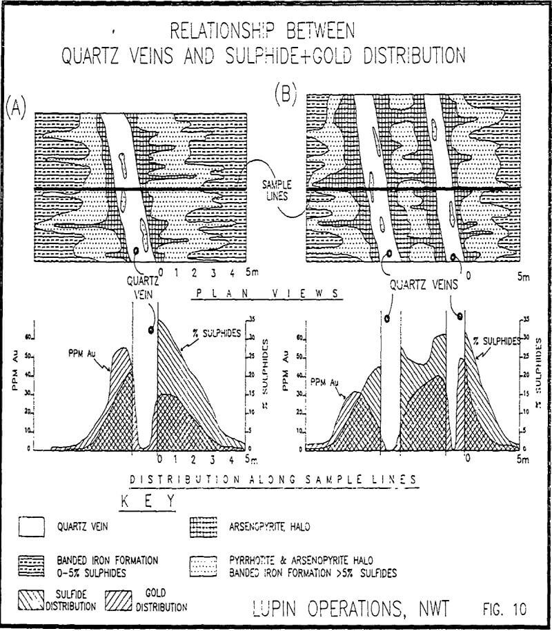
At Lupin, the close relationship between quartz veining, gold and sulfides has been recognized by some workers, including the authors, for several years. However, it is primarily in the poorly mineralized portions of the iron formation, or at the margins of mineralized “shoots”, where the vein/sulfide/gold relationships can be clearly observed. Quartz veining is found throughout the deposit, although vein densities vary. Individual vein thickness range from about 1 metre to a few millimetres.
Sampling Methodology
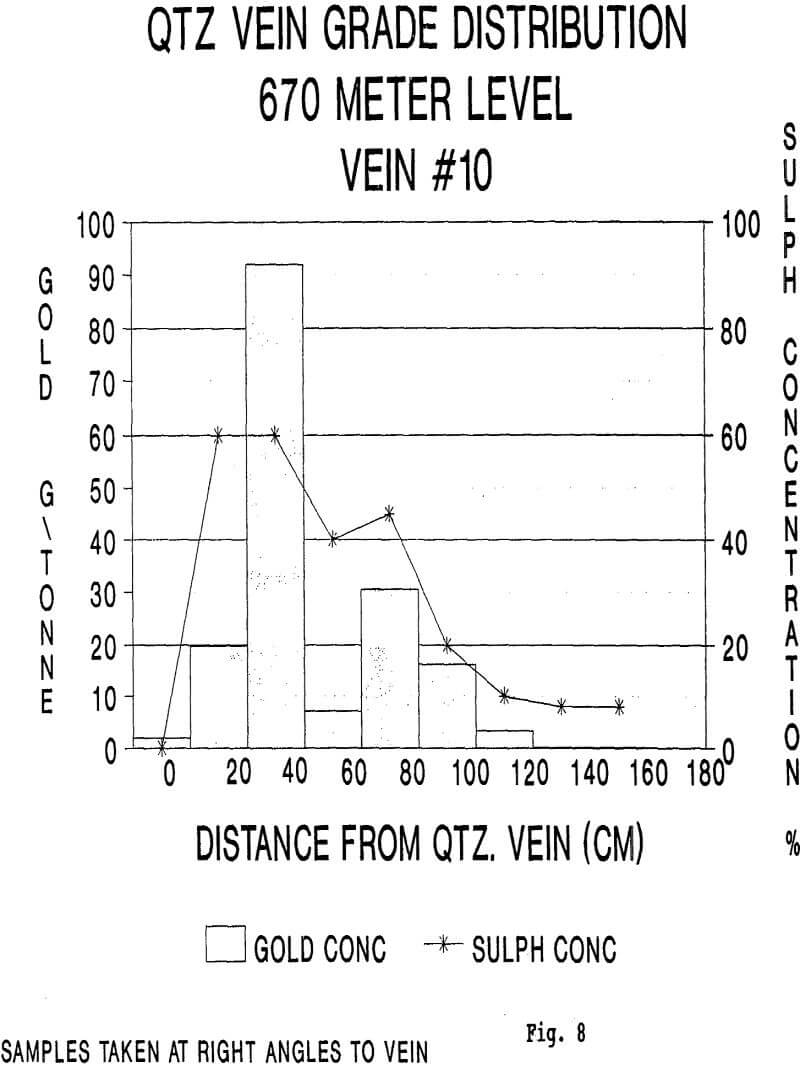
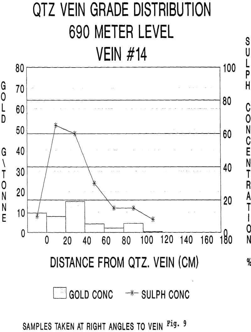
Quartz vein locations for the study were selected in the Centre Zone on 670 and 690 metre levels where veins are well separated from each other so that their sulfide haloes do not overlap. The selection was made in order to more accurately document the relationships between individual veins and the banded iron formation.
Distribution of Gold and Sulfides
Sulfides account for 10-30% of the sulfide-rich iron formation and less than 5% of the sulfide-poor iron formation. These sulfide concentrations are mine-wide averages and do not reflect the significant degree of local variability in sulfide concentration.
The characteristic texture and sulfide content extends up to 20-40 centimetres away from the quartz vein and the zone then grades laterally into an arsenide-poor zone. Here, minor coarse to medium prismatic arsenopyrite is present with the majority of the sulfides being coarse- to medium-grained pyrrhotite. The second zone persists up to about 80 centimetres away from the quartz vein and shows overall sulfide concentrations of 25-45%. In turn, it grades laterally into an arsenide-free zone with massive to disseminated pyrrhotite grading from 25% to a “normal sulfide rich” content of 10-20%.
Deposit-Scale Zonation of Gold Values
Variations in gold concentration at the margins of the high and low grade zones are sharp over lateral distances of 20 metres or less. All levels in the Centre and West Zones pass through two or more of these zones. On some levels, notably 170 through 330 metre levels in the Centre Zone, drifts pass through high grade zones at both ends and have a low grade section in the middle, which results in higher than average grades for these levels.